Ganshui elevation
Ganshui (Chongqing), China elevation is 414 meters and Ganshui elevation in feet is 1358 ft above sea level [src 1]. Ganshui is a seat of a fourth-order administrative division (feature code) with elevation that is 144 meters (472 ft) smaller than average city elevation in China.
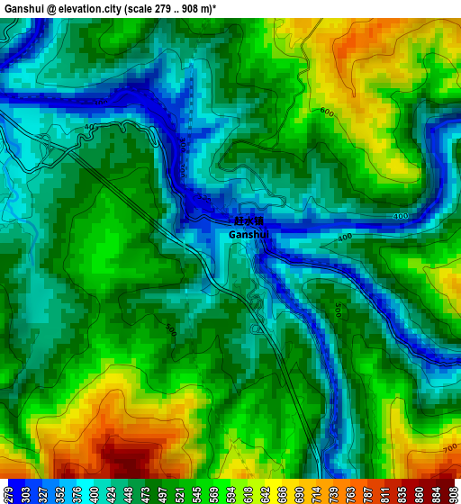
Below is the Elevation map of Ganshui, which displays elevation range with different colors. Scale of the first map is from 279 to 908 m (915 to 2979 ft) with average elevation of 497 meters (=1631 ft) [note 1]
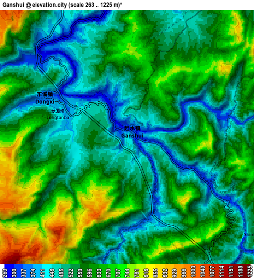
These maps also provides idea of topography and contour of this city, they are displayed at different zoom levels. More info about maps, scale and edge coordinates you can find below images.
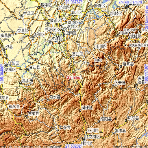
| \ | Map #1 | Map #2 | Topo.Map |
| Scale [m] | 279..908 m | 263..1225 m | × |
| Scale [ft] | 915..2979 ft | 863..4019 ft | × |
| Average | 497 m = 1631 ft | 577.8 m = 1896 ft | × |
| Width | 8.57 km = 5.3 mi | 17.14 km = 10.7 mi | 274.2 km = 170.4 mi |
| Height | 8.57 km = 5.3 mi | 17.14 km = 10.7 mi | 274.2 km = 170.4 mi |
| ↑Max Latitude | 28.780744° | 28.819253° | 29.96787° |
| Latitude at center | 28.74222° | 28.74222° | 28.74222° |
| ↓Min Latitude | 28.703682° | 28.66513° | 27.50202° |
| ← Min Longitude | 106.667165° | 106.623219° | 105.30486° |
| Longitude center | 106.71111° | 106.71111° | 106.71111° |
| →Max Longitude | 106.755055° | 106.799001° | 108.11736° |
Nearby cities:
Cities around Ganshui sort by population:
• Dongxi elevation 389 m
5.3 km,  293°
293°
• Wenshui 1039 m
37.1 km,  209°
209°
• Songkan 425 m
25.9 km,  145°
145°
• Xinzhan 528 m
41.8 km,  160°
160°
• Caijia 330 m
40.6 km,  297°
297°
• Shijiaochang 365 m
20.7 km,  12°
12°
• Sanchahe 1157 m
38.9 km,  225°
225°
• Liangcunchang 1070 m
46.6 km,  216°
216°
• Puhechang 304 m
26.1 km,  26°
26°
• Guofuchang 649 m
16.1 km,  318°
318°
• Wansheng 324 m
32.4 km,  40°
40°
• Gunan 297 m
31.8 km,  348°
348°
Multilingual:
 En español:
Ganshui elevación 414 m.
 En France:
Ganshui élévation 414 m.


Sources and notes:
- [note 1] Map square and city borders are not equal. Map elevation data is calculated only from area inside that square.
- [src 1] Elevation data from geonames database provided with same terms of usage.
- [src 2] The elevation map of Ganshui is generated using elevation data from NASA's 3 arcsec (90m) resolution SRTM data.
- [src 3] Base (background) map © OpenStreetMap contributors tiles are generated by Geofabrik and OpenTopoMap.
Copyright & License:
This Ganshui Elevation Map is licensed under CC BY-SA. You may reuse any part from this page, if you give a proper credit by linking to this URL:
 More info on terms of use page.