Wansheng elevation
Wansheng (Chongqing), China elevation is 324 meters and Wansheng elevation in feet is 1063 ft above sea level [src 1]. Wansheng is a seat of a third-order administrative division (feature code) with elevation that is 234 meters (768 ft) smaller than average city elevation in China.
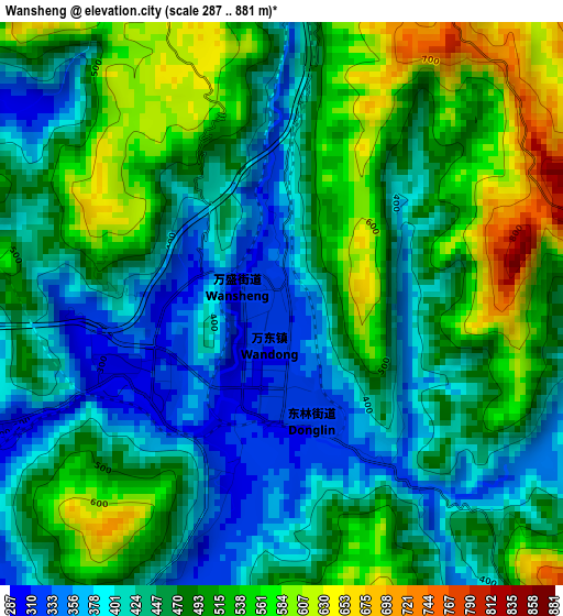
Below is the Elevation map of Wansheng, which displays elevation range with different colors. Scale of the first map is from 287 to 881 m (942 to 2890 ft) with average elevation of 469.3 meters (=1540 ft) [note 1]
These maps also provides idea of topography and contour of this city, they are displayed at different zoom levels. More info about maps, scale and edge coordinates you can find below images.
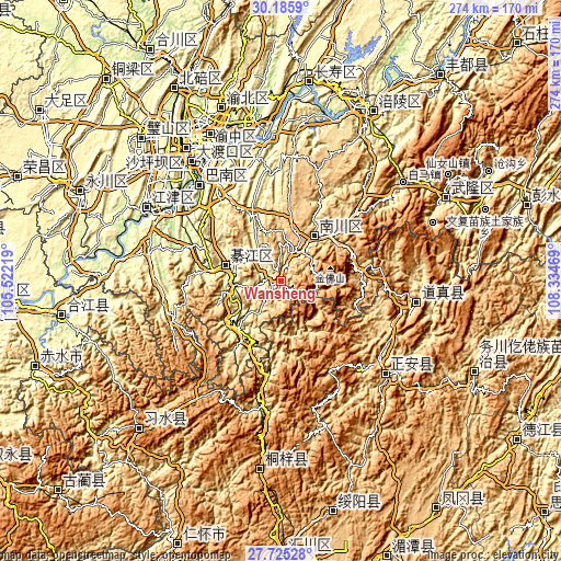
| \ | Map #1 | Topo.Map |
| Scale [m] | 287..881 m | × |
| Scale [ft] | 942..2890 ft | × |
| Average | 469.3 m = 1540 ft | × |
| Width | 8.55 km = 5.3 mi | 273.6 km = 170 mi |
| Height | 8.55 km = 5.3 mi | 273.6 km = 170 mi |
| ↑Max Latitude | 29.001342° | 30.1859° |
| Latitude at center | 28.9629° | 28.9629° |
| ↓Min Latitude | 28.924444° | 27.72528° |
| ← Min Longitude | 106.884495° | 105.52219° |
| Longitude center | 106.92844° | 106.92844° |
| →Max Longitude | 106.972385° | 108.33469° |
Nearby cities:
Cities around Wansheng sort by population:
• Yudong elevation 212 m
61.5 km,  319°
319°
• Dongxi 389 m
34.3 km,  229°
229°
• Ganshui 414 m
32.4 km,  220°
220°
• Songkan 425 m
46.4 km,  188°
188°
• Xinzhan 528 m
64.3 km, 186°
• Caijia 330 m
57.5 km,  264°
264°
• Shijiaochang 365 m
17.3 km, 255°
• Puhechang 304 m
9.5 km, 263°
• Guofuchang 649 m
34.2 km,  248°
248°
• Longzhouwan 216 m
59.7 km, 320°
• Gunan 297 m
28.1 km,  283°
283°
• Dongcheng 538 m
27 km,  38°
38°
Multilingual:
 En español:
Wansheng elevación 324 m.
 En France:
Wansheng élévation 324 m.
 Auf Deutsch:
Wansheng höhe über dem Meeresspiegel ist 324 m.

Sources and notes:
- [note 1] Map square and city borders are not equal. Map elevation data is calculated only from area inside that square.
- [src 1] Elevation data from geonames database provided with same terms of usage.
- [src 2] The elevation map of Wansheng is generated using elevation data from NASA's 3 arcsec (90m) resolution SRTM data.
- [src 3] Base (background) map © OpenStreetMap contributors tiles are generated by Geofabrik and OpenTopoMap.
Copyright & License:
This Wansheng Elevation Map is licensed under CC BY-SA. You may reuse any part from this page, if you give a proper credit by linking to this URL:
 More info on terms of use page.