Gushi Chengguanzhen elevation
Gushi Chengguanzhen (Henan), China elevation is 56 meters and Gushi Chengguanzhen elevation in feet is 184 ft above sea level [src 1]. Gushi Chengguanzhen is a seat of a third-order administrative division (feature code) with elevation that is 502 meters (1647 ft) smaller than average city elevation in China.
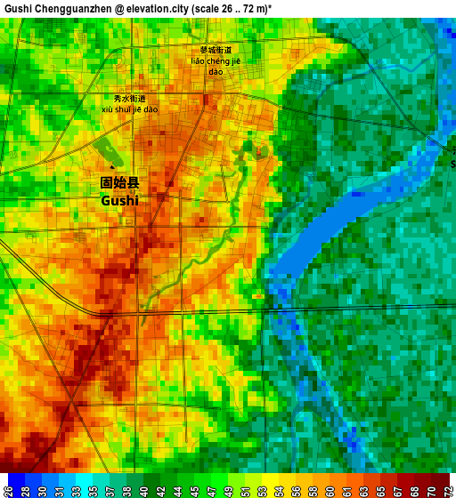
Below is the Elevation map of Gushi Chengguanzhen, which displays elevation range with different colors. Scale of the first map is from 26 to 72 m (85 to 236 ft) with average elevation of 48.2 meters (=158 ft) [note 1]
These maps also provides idea of topography and contour of this city, they are displayed at different zoom levels. More info about maps, scale and edge coordinates you can find below images.
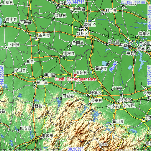
| \ | Map #1 | Topo.Map |
| Scale [m] | 26..72 m | × |
| Scale [ft] | 85..236 ft | × |
| Average | 48.2 m = 158 ft | × |
| Width | 8.27 km = 5.1 mi | 264.7 km = 164.5 mi |
| Height | 8.27 km = 5.1 mi | 264.7 km = 164.5 mi |
| ↑Max Latitude | 32.199274° | 33.34471° |
| Latitude at center | 32.16208° | 32.16208° |
| ↓Min Latitude | 32.124871° | 30.9639° |
| ← Min Longitude | 115.625945° | 114.26364° |
| Longitude center | 115.66989° | 115.66989° |
| →Max Longitude | 115.713835° | 117.07614° |
Nearby cities:
Cities around Gushi Chengguanzhen sort by population:
• Fuyang elevation 31 m
83.2 km,  9°
9°
• Wuyang 33 m
57.6 km,  109°
109°
• Dingcheng 34 m
59.5 km,  266°
266°
• Huoqiu Chengguanzhen 30 m
62.5 km,  69°
69°
• Yingshang Chengguanzhen 26 m
76.7 km,  47°
47°
• Xincai 41 m
91.8 km,  314°
314°
• Xi Xian Chengguanzhen 54 m
90.7 km,  282°
282°
• Zishui 54 m
74.4 km,  256°
256°
• Meishan 80 m
53.3 km,  154°
154°
• Funan Chengguanzhen 33 m
53 km,  354°
354°
• Shangcheng Chengguanzhen 83 m
48 km,  211°
211°
• Huaibin Chengguanzhen 37 m
41.6 km,  323°
323°
Multilingual:
 En español:
Gushi Chengguanzhen elevación 56 m.
 En France:
Gushi Chengguanzhen élévation 56 m.
 Auf Deutsch:
Gushi Chengguanzhen höhe über dem Meeresspiegel ist 56 m.
 На русском:
Gushi Chengguanzhen высота над уровнем моря 56 м
Sources and notes:
- [note 1] Map square and city borders are not equal. Map elevation data is calculated only from area inside that square.
- [src 1] Elevation data from geonames database provided with same terms of usage.
- [src 2] The elevation map of Gushi Chengguanzhen is generated using elevation data from NASA's 3 arcsec (90m) resolution SRTM data.
- [src 3] Base (background) map © OpenStreetMap contributors tiles are generated by Geofabrik and OpenTopoMap.
Copyright & License:
This Gushi Chengguanzhen Elevation Map is licensed under CC BY-SA. You may reuse any part from this page, if you give a proper credit by linking to this URL:
 More info on terms of use page.