Meishan elevation
Meishan (Anhui), China elevation is 80 meters and Meishan elevation in feet is 262 ft above sea level [src 1]. Meishan is a seat of a third-order administrative division (feature code) with elevation that is 478 meters (1568 ft) smaller than average city elevation in China.
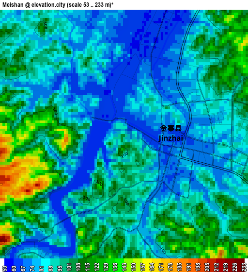
Below is the Elevation map of Meishan, which displays elevation range with different colors. Scale of the first map is from 53 to 233 m (174 to 764 ft) with average elevation of 91.7 meters (=301 ft) [note 1]
These maps also provides idea of topography and contour of this city, they are displayed at different zoom levels. More info about maps, scale and edge coordinates you can find below images.
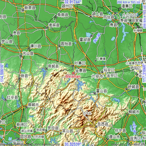
| \ | Map #1 | Topo.Map |
| Scale [m] | 53..233 m | × |
| Scale [ft] | 174..764 ft | × |
| Average | 91.7 m = 301 ft | × |
| Width | 8.31 km = 5.2 mi | 266 km = 165.3 mi |
| Height | 8.31 km = 5.2 mi | 266 km = 165.3 mi |
| ↑Max Latitude | 31.7665° | 32.91744° |
| Latitude at center | 31.72913° | 31.72913° |
| ↓Min Latitude | 31.691745° | 30.52539° |
| ← Min Longitude | 115.868465° | 114.50616° |
| Longitude center | 115.91241° | 115.91241° |
| →Max Longitude | 115.956355° | 117.31866° |
Nearby cities:
Cities around Meishan sort by population:
• Macheng elevation 57 m
104.2 km,  234°
234°
• Wuyang 33 m
43.1 km,  47°
47°
• Dingcheng 34 m
93.5 km,  298°
298°
• Huoqiu Chengguanzhen 30 m
78.3 km,  27°
27°
• Shucheng Chengguanzhen 22 m
102.4 km,  106°
106°
• Zishui 54 m
100.4 km,  287°
287°
• Wenquan 430 m
99.9 km,  191°
191°
• Xinji 87 m
99 km,  263°
263°
• Huaibin Chengguanzhen 37 m
94.5 km,  329°
329°
• Lu’an 73 m
57.2 km,  89°
89°
• Gushi Chengguanzhen 56 m
53.3 km, 334°
• Shangcheng Chengguanzhen 83 m
48.9 km,  278°
278°
Multilingual:
 En español:
Meishan elevación 80 m.
 En France:
Meishan élévation 80 m.


Sources and notes:
- [note 1] Map square and city borders are not equal. Map elevation data is calculated only from area inside that square.
- [src 1] Elevation data from geonames database provided with same terms of usage.
- [src 2] The elevation map of Meishan is generated using elevation data from NASA's 3 arcsec (90m) resolution SRTM data.
- [src 3] Base (background) map © OpenStreetMap contributors tiles are generated by Geofabrik and OpenTopoMap.
Copyright & License:
This Meishan Elevation Map is licensed under CC BY-SA. You may reuse any part from this page, if you give a proper credit by linking to this URL:
 More info on terms of use page.