Hanjia elevation
Hanjia (Chongqing), China elevation is 295 meters and Hanjia elevation in feet is 968 ft above sea level [src 1]. Hanjia is a seat of a third-order administrative division (feature code) with elevation that is 263 meters (863 ft) smaller than average city elevation in China.
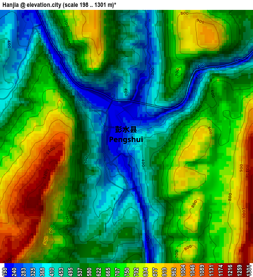
Below is the Elevation map of Hanjia, which displays elevation range with different colors. Scale of the first map is from 198 to 1301 m (650 to 4268 ft) with average elevation of 624 meters (=2047 ft) [note 1]
These maps also provides idea of topography and contour of this city, they are displayed at different zoom levels. More info about maps, scale and edge coordinates you can find below images.
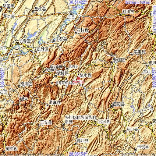
| \ | Map #1 | Topo.Map |
| Scale [m] | 198..1301 m | × |
| Scale [ft] | 650..4268 ft | × |
| Average | 624 m = 2047 ft | × |
| Width | 8.52 km = 5.3 mi | 272.7 km = 169.4 mi |
| Height | 8.52 km = 5.3 mi | 272.7 km = 169.4 mi |
| ↑Max Latitude | 29.333558° | 30.51422° |
| Latitude at center | 29.29524° | 29.29524° |
| ↓Min Latitude | 29.256908° | 28.06154° |
| ← Min Longitude | 108.117375° | 106.75507° |
| Longitude center | 108.16132° | 108.16132° |
| →Max Longitude | 108.205265° | 109.56757° |
Nearby cities:
Cities around Hanjia sort by population:
• Fuling elevation 263 m
87 km,  301°
301°
• Gaoleshan 739 m
104.3 km,  65°
65°
• Dongcheng 538 m
103.9 km,  261°
261°
• Duru 649 m
89.7 km,  197°
197°
• Heping 292 m
88 km,  158°
158°
• Lizhi 287 m
86.9 km, 301°
• Nanbin 549 m
78.5 km,  356°
356°
• Zhongduo 672 m
76.9 km,  130°
130°
• Sanhe 224 m
76.2 km,  326°
326°
• Yuxi 686 m
71.3 km,  230°
230°
• Qianjiang 582 m
65 km, 66°
• Xiangkou 205 m
41.3 km,  275°
275°
Multilingual:
 En español:
Hanjia elevación 295 m.
 En France:
Hanjia élévation 295 m.


Sources and notes:
- [note 1] Map square and city borders are not equal. Map elevation data is calculated only from area inside that square.
- [src 1] Elevation data from geonames database provided with same terms of usage.
- [src 2] The elevation map of Hanjia is generated using elevation data from NASA's 3 arcsec (90m) resolution SRTM data.
- [src 3] Base (background) map © OpenStreetMap contributors tiles are generated by Geofabrik and OpenTopoMap.
Copyright & License:
This Hanjia Elevation Map is licensed under CC BY-SA. You may reuse any part from this page, if you give a proper credit by linking to this URL:
 More info on terms of use page.