Fuling elevation
Fuling (Chongqing), China elevation is 263 meters and Fuling elevation in feet is 863 ft above sea level [src 1]. Fuling is a populated place (feature code) with elevation that is 295 meters (968 ft) smaller than average city elevation in China.
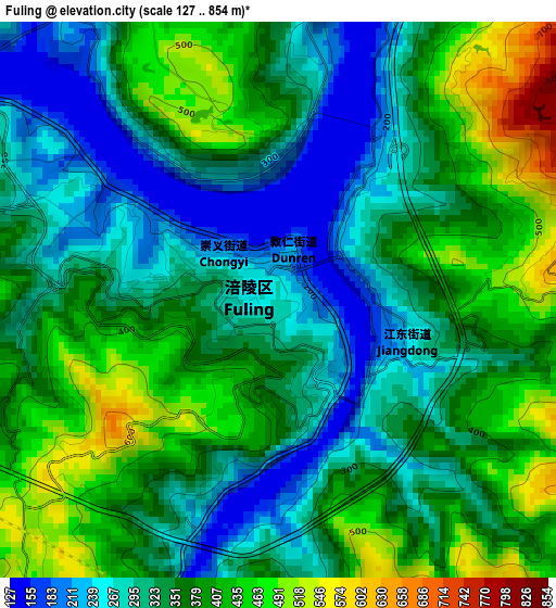
Below is the Elevation map of Fuling, which displays elevation range with different colors. Scale of the first map is from 127 to 854 m (417 to 2802 ft) with average elevation of 352.7 meters (=1157 ft) [note 1]
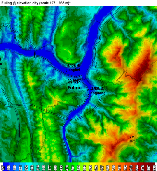
These maps also provides idea of topography and contour of this city, they are displayed at different zoom levels. More info about maps, scale and edge coordinates you can find below images.
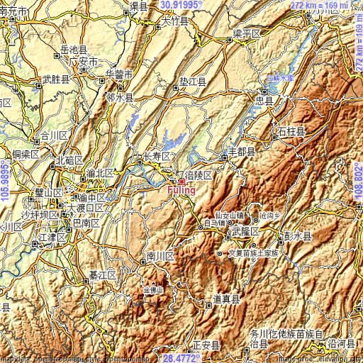
| \ | Map #1 | Map #2 | Topo.Map |
| Scale [m] | 127..854 m | 127..938 m | × |
| Scale [ft] | 417..2802 ft | 417..3077 ft | × |
| Average | 352.7 m = 1157 ft | 409.8 m = 1344 ft | × |
| Width | 8.49 km = 5.3 mi | 16.98 km = 10.6 mi | 271.6 km = 168.8 mi |
| Height | 8.49 km = 5.3 mi | 16.98 km = 10.6 mi | 271.6 km = 168.8 mi |
| ↑Max Latitude | 29.744163° | 29.782311° | 30.91995° |
| Latitude at center | 29.706° | 29.706° | 29.706° |
| ↓Min Latitude | 29.667823° | 29.629631° | 28.4772° |
| ← Min Longitude | 107.351805° | 107.307859° | 105.9895° |
| Longitude center | 107.39575° | 107.39575° | 107.39575° |
| →Max Longitude | 107.439695° | 107.483641° | 108.802° |
Nearby cities:
Cities around Fuling sort by population:
• Chongqing elevation 225 m
83 km,  258°
258°
• Dingping 356 m
83.6 km,  327°
327°
• Cuntan 245 m
80.6 km, 261°
• Nanping 256 m
80.2 km, 256°
• Nanbin 549 m
76.1 km,  64°
64°
• Shuangfengqiao 449 m
74.2 km,  271°
271°
• Guixi 412 m
69.9 km,  356°
356°
• Dongcheng 538 m
67.8 km,  204°
204°
• Xiangkou 205 m
53.2 km,  141°
141°
• Sanhe 224 m
37 km, 60°
• Fengcheng 305 m
34.8 km,  292°
292°
• Lizhi 287 m
0.3 km,  189°
189°
Multilingual:
 En español:
Fuling elevación 263 m.
 En France:
Fuling élévation 263 m.


Sources and notes:
- [note 1] Map square and city borders are not equal. Map elevation data is calculated only from area inside that square.
- [src 1] Elevation data from geonames database provided with same terms of usage.
- [src 2] The elevation map of Fuling is generated using elevation data from NASA's 3 arcsec (90m) resolution SRTM data.
- [src 3] Base (background) map © OpenStreetMap contributors tiles are generated by Geofabrik and OpenTopoMap.
Copyright & License:
This Fuling Elevation Map is licensed under CC BY-SA. You may reuse any part from this page, if you give a proper credit by linking to this URL:
 More info on terms of use page.