Fu’an elevation
Fu’an (Fujian), China elevation is 221 meters and Fu’an elevation in feet is 725 ft above sea level [src 1]. Fu’an is a seat of a third-order administrative division (feature code) with elevation that is 337 meters (1106 ft) smaller than average city elevation in China.
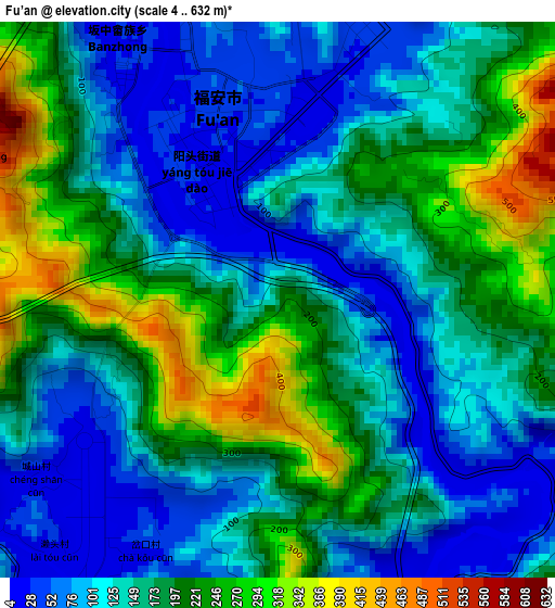
Below is the Elevation map of Fu’an, which displays elevation range with different colors. Scale of the first map is from 4 to 632 m (13 to 2073 ft) with average elevation of 161.4 meters (=530 ft) [note 1]
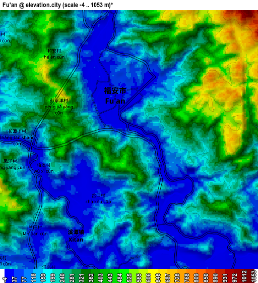
These maps also provides idea of topography and contour of this city, they are displayed at different zoom levels. More info about maps, scale and edge coordinates you can find below images.
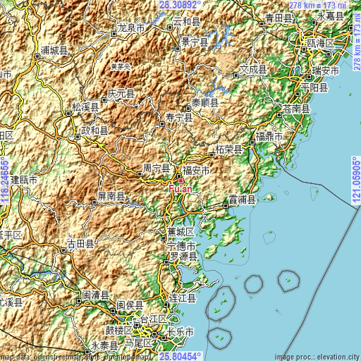
| \ | Map #1 | Map #2 | Topo.Map |
| Scale [m] | 4..632 m | -4..1053 m | × |
| Scale [ft] | 13..2073 ft | -13..3455 ft | × |
| Average | 161.4 m = 530 ft | 233.3 m = 765 ft | × |
| Width | 8.7 km = 5.4 mi | 17.4 km = 10.8 mi | 278.5 km = 173.1 mi |
| Height | 8.7 km = 5.4 mi | 17.4 km = 10.8 mi | 278.5 km = 173.1 mi |
| ↑Max Latitude | 27.102847° | 27.141959° | 28.30892° |
| Latitude at center | 27.06372° | 27.06372° | 27.06372° |
| ↓Min Latitude | 27.02458° | 26.985426° | 25.80454° |
| ← Min Longitude | 119.608855° | 119.564909° | 118.24655° |
| Longitude center | 119.6528° | 119.6528° | 119.6528° |
| →Max Longitude | 119.696745° | 119.740691° | 121.05905° |
Nearby cities:
Cities around Fu’an sort by population:
• Huotong elevation 43 m
33.3 km,  224°
224°
• Xiabaishi 43 m
27.7 km,  174°
174°
• Xibing 16 m
11.6 km,  142°
142°
• Badu 10 m
29.5 km,  197°
197°
• Chixi 122 m
23.9 km, 224°
• Yantian 23 m
31 km, 139°
• Chongru 247 m
29.8 km,  114°
114°
• Gantang 14 m
16.1 km,  186°
186°
• Dingtoucun 16 m
24.9 km,  178°
178°
• Xiancun 154 m
32.1 km,  244°
244°
• Zhouning 888 m
31.8 km,  278°
278°
• Zherong 666 m
30.9 km,  50°
50°
Multilingual:
 En español:
Fu’an elevación 221 m.
 En France:
Fu’an élévation 221 m.


Sources and notes:
- [note 1] Map square and city borders are not equal. Map elevation data is calculated only from area inside that square.
- [src 1] Elevation data from geonames database provided with same terms of usage.
- [src 2] The elevation map of Fu’an is generated using elevation data from NASA's 3 arcsec (90m) resolution SRTM data.
- [src 3] Base (background) map © OpenStreetMap contributors tiles are generated by Geofabrik and OpenTopoMap.
Copyright & License:
This Fu’an Elevation Map is licensed under CC BY-SA. You may reuse any part from this page, if you give a proper credit by linking to this URL:
 More info on terms of use page.