Zherong elevation
Zherong (Fujian), China elevation is 666 meters and Zherong elevation in feet is 2185 ft above sea level [src 1]. Zherong is a seat of a third-order administrative division (feature code) with elevation that is 108 meters (354 ft) bigger than average city elevation in China.
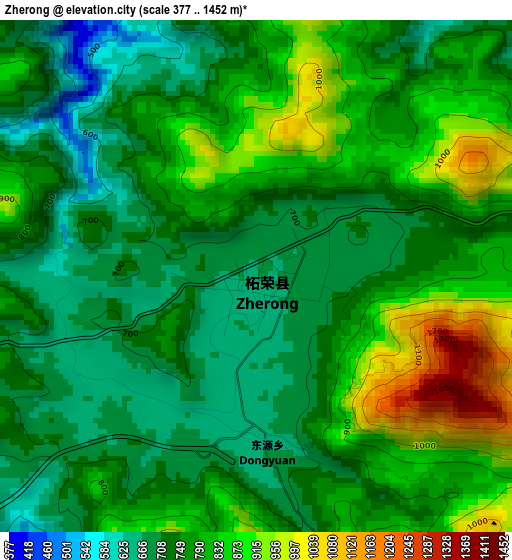
Below is the Elevation map of Zherong, which displays elevation range with different colors. Scale of the first map is from 377 to 1452 m (1237 to 4764 ft) with average elevation of 777.5 meters (=2551 ft) [note 1]
These maps also provides idea of topography and contour of this city, they are displayed at different zoom levels. More info about maps, scale and edge coordinates you can find below images.
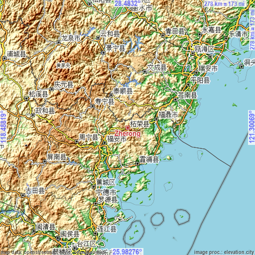
| \ | Map #1 | Topo.Map |
| Scale [m] | 377..1452 m | × |
| Scale [ft] | 1237..4764 ft | × |
| Average | 777.5 m = 2551 ft | × |
| Width | 8.69 km = 5.4 mi | 278 km = 172.7 mi |
| Height | 8.69 km = 5.4 mi | 278 km = 172.7 mi |
| ↑Max Latitude | 27.279065° | 28.4832° |
| Latitude at center | 27.24° | 27.24° |
| ↓Min Latitude | 27.200921° | 25.98276° |
| ← Min Longitude | 119.850495° | 118.48819° |
| Longitude center | 119.89444° | 119.89444° |
| →Max Longitude | 119.938385° | 121.30069° |
Nearby cities:
Cities around Zherong sort by population:
• Fu’an elevation 221 m
30.9 km,  230°
230°
• Fuding 13 m
33 km,  72°
72°
• Xiabaishi 43 m
51.8 km,  204°
204°
• Shajiang 13 m
51.4 km,  171°
171°
• Xibing 16 m
33.3 km,  210°
210°
• Chixi 122 m
54.7 km, 228°
• Yantian 23 m
43.1 km,  184°
184°
• Chongru 247 m
32.3 km, 174°
• Gantang 14 m
44 km,  215°
215°
• Dingtoucun 16 m
50.1 km, 207°
• Aoyang 767 m
45.8 km,  302°
302°
• Luoyang 516 m
40 km,  333°
333°
Multilingual:
 En español:
Zherong elevación 666 m.
 En France:
Zherong élévation 666 m.


Sources and notes:
- [note 1] Map square and city borders are not equal. Map elevation data is calculated only from area inside that square.
- [src 1] Elevation data from geonames database provided with same terms of usage.
- [src 2] The elevation map of Zherong is generated using elevation data from NASA's 3 arcsec (90m) resolution SRTM data.
- [src 3] Base (background) map © OpenStreetMap contributors tiles are generated by Geofabrik and OpenTopoMap.
Copyright & License:
This Zherong Elevation Map is licensed under CC BY-SA. You may reuse any part from this page, if you give a proper credit by linking to this URL:
 More info on terms of use page.