Longquan elevation
Longquan (Shanxi), China elevation is 1111 meters and Longquan elevation in feet is 3645 ft above sea level [src 1]. Longquan is a seat of a third-order administrative division (feature code) with elevation that is 553 meters (1814 ft) bigger than average city elevation in China.
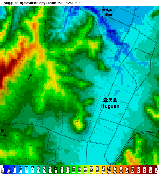
Below is the Elevation map of Longquan, which displays elevation range with different colors. Scale of the first map is from 980 to 1261 m (3215 to 4137 ft) with average elevation of 1068.5 meters (=3506 ft) [note 1]
These maps also provides idea of topography and contour of this city, they are displayed at different zoom levels. More info about maps, scale and edge coordinates you can find below images.
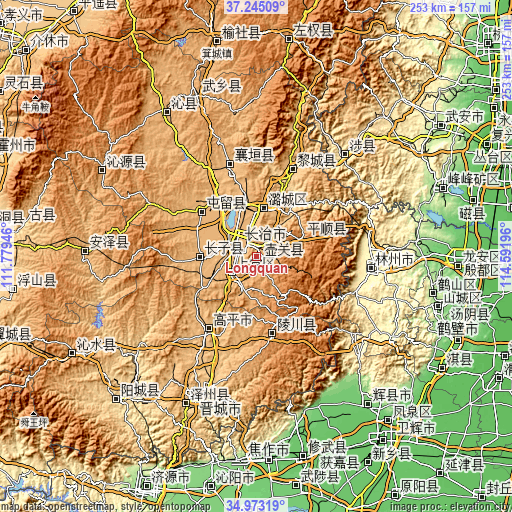
| \ | Map #1 | Topo.Map |
| Scale [m] | 980..1261 m | × |
| Scale [ft] | 3215..4137 ft | × |
| Average | 1068.5 m = 3506 ft | × |
| Width | 7.89 km = 4.9 mi | 252.6 km = 157 mi |
| Height | 7.89 km = 4.9 mi | 252.6 km = 157 mi |
| ↑Max Latitude | 36.152851° | 37.24509° |
| Latitude at center | 36.11736° | 36.11736° |
| ↓Min Latitude | 36.081852° | 34.97319° |
| ← Min Longitude | 113.141765° | 111.77946° |
| Longitude center | 113.18571° | 113.18571° |
| →Max Longitude | 113.229655° | 114.59196° |
Nearby cities:
Cities around Longquan sort by population:
• Jincheng elevation 711 m
75.4 km,  204°
204°
• Nancun 726 m
80.8 km,  205°
205°
• Kaiyuan 302 m
57.4 km,  95°
95°
• Guhan 890 m
48.7 km,  342°
342°
• Lihou 747 m
45.9 km,  21°
21°
• Chongwen 1184 m
38.5 km,  171°
171°
• Linjiang 920 m
35.9 km,  310°
310°
• Danzhu 952 m
29.2 km,  271°
271°
• Luhua 944 m
24.1 km,  8°
8°
• Qingyang 1180 m
23.1 km,  64°
64°
• Handian 971 m
15 km,  237°
237°
• Changzhi 937 m
10.3 km,  315°
315°
Multilingual:
 En español:
Longquan elevación 1111 m.
 En France:
Longquan élévation 1111 m.
 Auf Deutsch:
Longquan höhe über dem Meeresspiegel ist 1111 m.

Sources and notes:
- [note 1] Map square and city borders are not equal. Map elevation data is calculated only from area inside that square.
- [src 1] Elevation data from geonames database provided with same terms of usage.
- [src 2] The elevation map of Longquan is generated using elevation data from NASA's 3 arcsec (90m) resolution SRTM data.
- [src 3] Base (background) map © OpenStreetMap contributors tiles are generated by Geofabrik and OpenTopoMap.
Copyright & License:
This Longquan Elevation Map is licensed under CC BY-SA. You may reuse any part from this page, if you give a proper credit by linking to this URL:
 More info on terms of use page.