Jincheng elevation
Jincheng (Shanxi), China elevation is 711 meters and Jincheng elevation in feet is 2333 ft above sea level [src 1]. Jincheng is a seat of a second-order administrative division (feature code) with elevation that is 153 meters (502 ft) bigger than average city elevation in China.
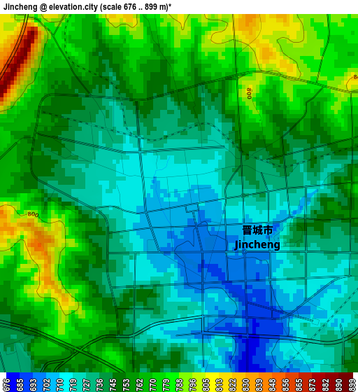
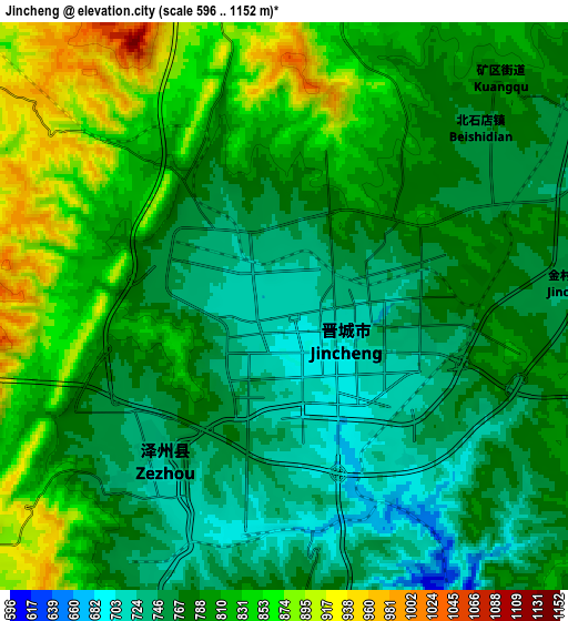
Below is the Elevation map of Jincheng, which displays elevation range with different colors. Scale of the first map is from 676 to 899 m (2218 to 2949 ft) with average elevation of 747.4 meters (=2452 ft) [note 1]
These maps also provides idea of topography and contour of this city, they are displayed at different zoom levels. More info about maps, scale and edge coordinates you can find below images.
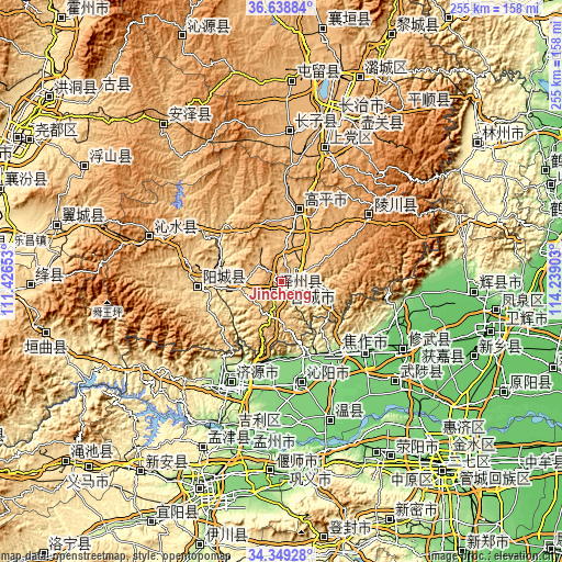
| \ | Map #1 | Map #2 | Topo.Map |
| Scale [m] | 676..899 m | 596..1152 m | × |
| Scale [ft] | 2218..2949 ft | 1955..3780 ft | × |
| Average | 747.4 m = 2452 ft | 793.3 m = 2603 ft | × |
| Width | 7.96 km = 4.9 mi | 15.91 km = 9.9 mi | 254.6 km = 158.2 mi |
| Height | 7.96 km = 4.9 mi | 15.91 km = 9.9 mi | 254.6 km = 158.2 mi |
| ↑Max Latitude | 35.537988° | 35.573739° | 36.63884° |
| Latitude at center | 35.50222° | 35.50222° | 35.50222° |
| ↓Min Latitude | 35.466436° | 35.430637° | 34.34928° |
| ← Min Longitude | 112.788835° | 112.744889° | 111.42653° |
| Longitude center | 112.83278° | 112.83278° | 112.83278° |
| →Max Longitude | 112.876725° | 112.920671° | 114.23903° |
Nearby cities:
Cities around Jincheng sort by population:
• Jiaozuo elevation 138 m
46.6 km,  128°
128°
• Xixiang 132 m
37.9 km,  175°
175°
• Longgang 1055 m
64.5 km,  288°
288°
• Handian 971 m
63.4 km,  17°
17°
• Xiuwu Chengguanzhen 87 m
62.6 km,  118°
118°
• Jiyuan 152 m
51.3 km,  206°
206°
• Chongwen 1184 m
48.4 km,  51°
51°
• Tanbei 120 m
47.1 km,  168°
168°
• Qinghua 125 m
42.9 km,  151°
151°
• Zhongzhan 190 m
41.5 km, 134°
• Yangcheng 655 m
38.8 km,  268°
268°
• Nancun 726 m
5.4 km,  217°
217°
Multilingual:
 En español:
Jincheng elevación 711 m.
 En France:
Jincheng élévation 711 m.
 Auf Deutsch:
Jincheng höhe über dem Meeresspiegel ist 711 m.

Sources and notes:
- [note 1] Map square and city borders are not equal. Map elevation data is calculated only from area inside that square.
- [src 1] Elevation data from geonames database provided with same terms of usage.
- [src 2] The elevation map of Jincheng is generated using elevation data from NASA's 3 arcsec (90m) resolution SRTM data.
- [src 3] Base (background) map © OpenStreetMap contributors tiles are generated by Geofabrik and OpenTopoMap.
Copyright & License:
This Jincheng Elevation Map is licensed under CC BY-SA. You may reuse any part from this page, if you give a proper credit by linking to this URL:
 More info on terms of use page.