Huicheng elevation
Huicheng (Anhui), China elevation is 133 meters and Huicheng elevation in feet is 436 ft above sea level [src 1]. Huicheng is a seat of a third-order administrative division (feature code) with elevation that is 425 meters (1394 ft) smaller than average city elevation in China.
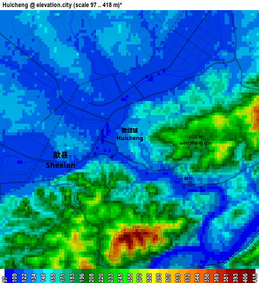
Below is the Elevation map of Huicheng, which displays elevation range with different colors. Scale of the first map is from 97 to 418 m (318 to 1371 ft) with average elevation of 157.4 meters (=516 ft) [note 1]
These maps also provides idea of topography and contour of this city, they are displayed at different zoom levels. More info about maps, scale and edge coordinates you can find below images.
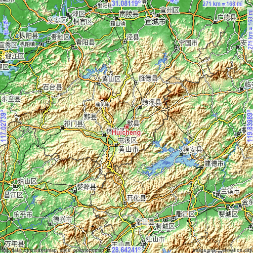
| \ | Map #1 | Topo.Map |
| Scale [m] | 97..418 m | × |
| Scale [ft] | 318..1371 ft | × |
| Average | 157.4 m = 516 ft | × |
| Width | 8.47 km = 5.3 mi | 271.2 km = 168.5 mi |
| Height | 8.47 km = 5.3 mi | 271.2 km = 168.5 mi |
| ↑Max Latitude | 29.907351° | 31.08119° |
| Latitude at center | 29.86925° | 29.86925° |
| ↓Min Latitude | 29.831135° | 28.64241° |
| ← Min Longitude | 118.389695° | 117.02739° |
| Longitude center | 118.43364° | 118.43364° |
| →Max Longitude | 118.477585° | 119.83989° |
Nearby cities:
Cities around Huicheng sort by population:
• Huangshan elevation 134 m
21.1 km,  213°
213°
• Wucheng 149 m
38.9 km,  219°
219°
• Jingchuan 35 m
91.2 km,  358°
358°
• Ziyang 93 m
88.8 km, 219°
• Kaihua Chengguanzhen 134 m
80.5 km,  181°
181°
• Qishan 164 m
68.9 km,  267°
267°
• Gantang 180 m
55.8 km,  328°
328°
• Jingyang 188 m
48.2 km,  12°
12°
• Biyang 203 m
47.4 km,  278°
278°
• Huayang 175 m
27 km,  33°
33°
• Haiyang 157 m
26.4 km,  249°
249°
• Yansi 136 m
10.5 km,  241°
241°
Multilingual:
 En español:
Huicheng elevación 133 m.
 En France:
Huicheng élévation 133 m.
 Auf Deutsch:
Huicheng höhe über dem Meeresspiegel ist 133 m.

Sources and notes:
- [note 1] Map square and city borders are not equal. Map elevation data is calculated only from area inside that square.
- [src 1] Elevation data from geonames database provided with same terms of usage.
- [src 2] The elevation map of Huicheng is generated using elevation data from NASA's 3 arcsec (90m) resolution SRTM data.
- [src 3] Base (background) map © OpenStreetMap contributors tiles are generated by Geofabrik and OpenTopoMap.
Copyright & License:
This Huicheng Elevation Map is licensed under CC BY-SA. You may reuse any part from this page, if you give a proper credit by linking to this URL:
 More info on terms of use page.