Kaihua Chengguanzhen elevation
Kaihua Chengguanzhen (Zhejiang), China elevation is 134 meters and Kaihua Chengguanzhen elevation in feet is 440 ft above sea level [src 1]. Kaihua Chengguanzhen is a seat of a third-order administrative division (feature code) with elevation that is 424 meters (1391 ft) smaller than average city elevation in China.
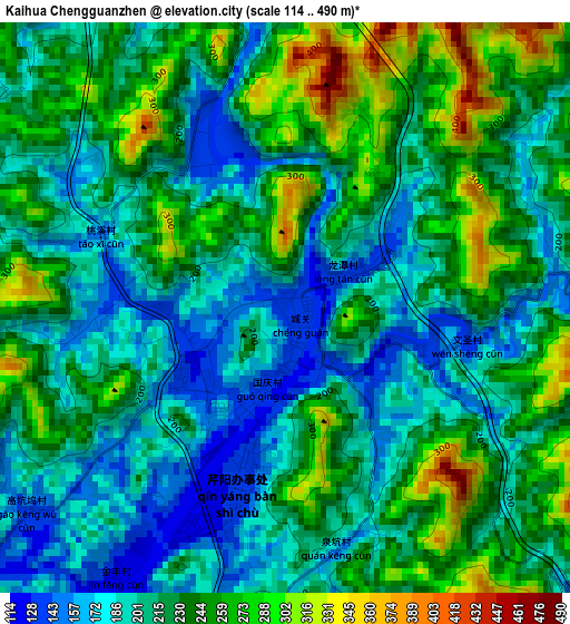
Below is the Elevation map of Kaihua Chengguanzhen, which displays elevation range with different colors. Scale of the first map is from 114 to 490 m (374 to 1608 ft) with average elevation of 220.5 meters (=723 ft) [note 1]
These maps also provides idea of topography and contour of this city, they are displayed at different zoom levels. More info about maps, scale and edge coordinates you can find below images.
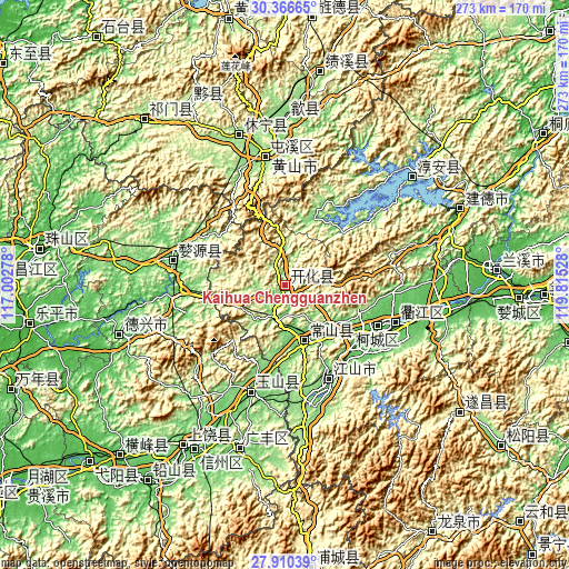
| \ | Map #1 | Topo.Map |
| Scale [m] | 114..490 m | × |
| Scale [ft] | 374..1608 ft | × |
| Average | 220.5 m = 723 ft | × |
| Width | 8.54 km = 5.3 mi | 273.1 km = 169.7 mi |
| Height | 8.54 km = 5.3 mi | 273.1 km = 169.7 mi |
| ↑Max Latitude | 29.184234° | 30.36665° |
| Latitude at center | 29.14586° | 29.14586° |
| ↓Min Latitude | 29.107472° | 27.91039° |
| ← Min Longitude | 118.365085° | 117.00278° |
| Longitude center | 118.40903° | 118.40903° |
| →Max Longitude | 118.452975° | 119.81528° |
Nearby cities:
Cities around Kaihua Chengguanzhen sort by population:
• Shangrao elevation 84 m
89.5 km,  210°
210°
• Quzhou 77 m
49.2 km,  114°
114°
• Huangshan 134 m
63.6 km,  351°
351°
• Wucheng 149 m
55.4 km,  335°
335°
• Lanjiang 42 m
102.4 km,  85°
85°
• Biyang 203 m
97.9 km,  332°
332°
• Xuri 90 m
92.3 km, 211°
• Xin’anjiang 49 m
91.3 km,  66°
66°
• Huicheng 133 m
80.5 km,  1°
1°
• Yansi 136 m
75.7 km, 354°
• Haiyang 157 m
74.7 km, 342°
• Ziyang 93 m
55 km,  282°
282°
Multilingual:
 En español:
Kaihua Chengguanzhen elevación 134 m.
 En France:
Kaihua Chengguanzhen élévation 134 m.
 Auf Deutsch:
Kaihua Chengguanzhen höhe über dem Meeresspiegel ist 134 m.
 На русском:
Kaihua Chengguanzhen высота над уровнем моря 134 м
Sources and notes:
- [note 1] Map square and city borders are not equal. Map elevation data is calculated only from area inside that square.
- [src 1] Elevation data from geonames database provided with same terms of usage.
- [src 2] The elevation map of Kaihua Chengguanzhen is generated using elevation data from NASA's 3 arcsec (90m) resolution SRTM data.
- [src 3] Base (background) map © OpenStreetMap contributors tiles are generated by Geofabrik and OpenTopoMap.
Copyright & License:
This Kaihua Chengguanzhen Elevation Map is licensed under CC BY-SA. You may reuse any part from this page, if you give a proper credit by linking to this URL:
 More info on terms of use page.