Jiangkou elevation
Jiangkou (Sichuan), China elevation is 379 meters and Jiangkou elevation in feet is 1243 ft above sea level [src 1]. Jiangkou is a seat of a third-order administrative division (feature code) with elevation that is 179 meters (587 ft) smaller than average city elevation in China.
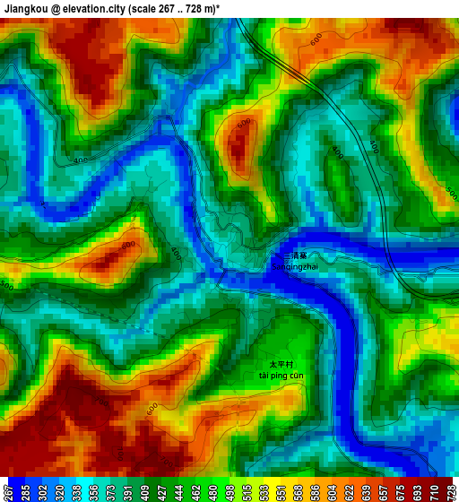
Below is the Elevation map of Jiangkou, which displays elevation range with different colors. Scale of the first map is from 267 to 728 m (876 to 2388 ft) with average elevation of 452.2 meters (=1484 ft) [note 1]
These maps also provides idea of topography and contour of this city, they are displayed at different zoom levels. More info about maps, scale and edge coordinates you can find below images.
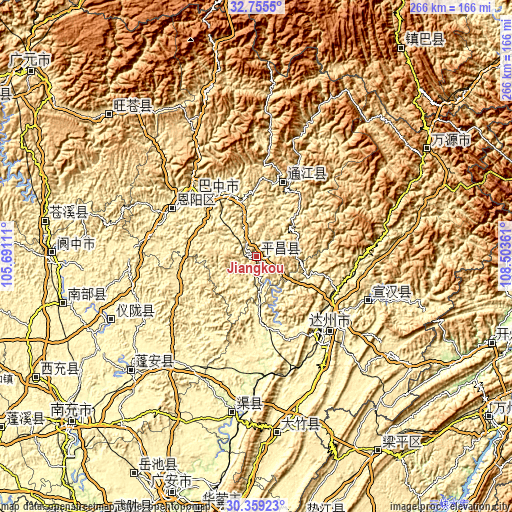
| \ | Map #1 | Topo.Map |
| Scale [m] | 267..728 m | × |
| Scale [ft] | 876..2388 ft | × |
| Average | 452.2 m = 1484 ft | × |
| Width | 8.33 km = 5.2 mi | 266.4 km = 165.5 mi |
| Height | 8.33 km = 5.2 mi | 266.4 km = 165.5 mi |
| ↑Max Latitude | 31.602496° | 32.7555° |
| Latitude at center | 31.56506° | 31.56506° |
| ↓Min Latitude | 31.527609° | 30.35923° |
| ← Min Longitude | 107.053415° | 105.69111° |
| Longitude center | 107.09736° | 107.09736° |
| →Max Longitude | 107.141305° | 108.50361° |
Nearby cities:
Cities around Jiangkou sort by population:
• Dazhou elevation 309 m
54.5 km,  135°
135°
• Changchi 732 m
78.4 km,  328°
328°
• Xialiang 550 m
64.7 km, 331°
• Zhoukou 320 m
88.6 km,  228°
228°
• Xinzheng 333 m
83.4 km,  247°
247°
• Qujiang 284 m
81.3 km,  188°
188°
• Langchi 335 m
74 km,  223°
223°
• Nanwai 313 m
55.6 km, 136°
• Xiwai 314 m
52.8 km, 137°
• Bazhong 455 m
47.5 km,  315°
315°
• Bazhou 366 m
44.6 km, 316°
• Nuojiang 395 m
41.3 km,  19°
19°
Multilingual:
 En español:
Jiangkou elevación 379 m.
 En France:
Jiangkou élévation 379 m.
 Auf Deutsch:
Jiangkou höhe über dem Meeresspiegel ist 379 m.

Sources and notes:
- [note 1] Map square and city borders are not equal. Map elevation data is calculated only from area inside that square.
- [src 1] Elevation data from geonames database provided with same terms of usage.
- [src 2] The elevation map of Jiangkou is generated using elevation data from NASA's 3 arcsec (90m) resolution SRTM data.
- [src 3] Base (background) map © OpenStreetMap contributors tiles are generated by Geofabrik and OpenTopoMap.
Copyright & License:
This Jiangkou Elevation Map is licensed under CC BY-SA. You may reuse any part from this page, if you give a proper credit by linking to this URL:
 More info on terms of use page.