Qujiang elevation
Qujiang (Sichuan), China elevation is 284 meters and Qujiang elevation in feet is 932 ft above sea level [src 1]. Qujiang is a seat of a third-order administrative division (feature code) with elevation that is 274 meters (899 ft) smaller than average city elevation in China.
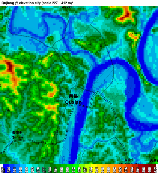
Below is the Elevation map of Qujiang, which displays elevation range with different colors. Scale of the first map is from 227 to 412 m (745 to 1352 ft) with average elevation of 271.5 meters (=891 ft) [note 1]
These maps also provides idea of topography and contour of this city, they are displayed at different zoom levels. More info about maps, scale and edge coordinates you can find below images.
| \ | Map #1 | Topo.Map |
| Scale [m] | 227..412 m | × |
| Scale [ft] | 745..1352 ft | × |
| Average | 271.5 m = 891 ft | × |
| Width | 8.39 km = 5.2 mi | 268.5 km = 166.8 mi |
| Height | 8.39 km = 5.2 mi | 268.5 km = 166.8 mi |
| ↑Max Latitude | 30.879783° | 32.04179° |
| Latitude at center | 30.84206° | 30.84206° |
| ↓Min Latitude | 30.804322° | 29.62714° |
| ← Min Longitude | 106.923905° | 105.5616° |
| Longitude center | 106.96785° | 106.96785° |
| →Max Longitude | 107.011795° | 108.3741° |
Nearby cities:
Cities around Qujiang sort by population:
• Dazhou elevation 309 m
65.6 km,  50°
50°
• Xinzheng 333 m
80.7 km,  306°
306°
• Guixi 412 m
67.1 km,  147°
147°
• Nanwai 313 m
65.1 km, 51°
• Xiwai 314 m
63.8 km, 49°
• Jiulong 387 m
61.1 km,  236°
236°
• Zhoukou 320 m
58.1 km,  291°
291°
• Dingping 356 m
56.1 km,  183°
183°
• Shuanghejiedao 256 m
55.2 km,  199°
199°
• Guang’an 244 m
51.7 km,  217°
217°
• Langchi 335 m
46.6 km,  304°
304°
• Zhuyang 400 m
25.2 km,  117°
117°
Multilingual:
 En español:
Qujiang elevación 284 m.
 En France:
Qujiang élévation 284 m.


Sources and notes:
- [note 1] Map square and city borders are not equal. Map elevation data is calculated only from area inside that square.
- [src 1] Elevation data from geonames database provided with same terms of usage.
- [src 2] The elevation map of Qujiang is generated using elevation data from NASA's 3 arcsec (90m) resolution SRTM data.
- [src 3] Base (background) map © OpenStreetMap contributors tiles are generated by Geofabrik and OpenTopoMap.
Copyright & License:
This Qujiang Elevation Map is licensed under CC BY-SA. You may reuse any part from this page, if you give a proper credit by linking to this URL:
 More info on terms of use page.