Kunyang elevation
Kunyang (Zhejiang), China elevation is 146 meters and Kunyang elevation in feet is 479 ft above sea level [src 1]. Kunyang is a populated place (feature code) with elevation that is 412 meters (1352 ft) smaller than average city elevation in China.
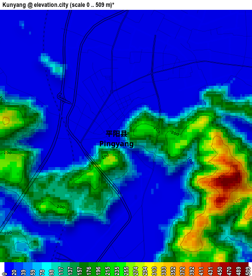
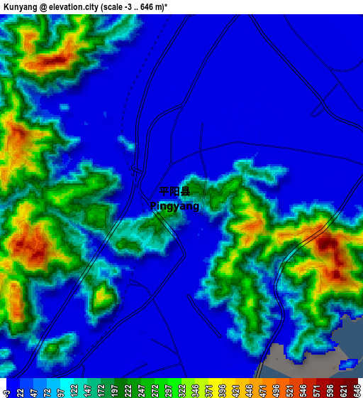
Below is the Elevation map of Kunyang, which displays elevation range with different colors. Scale of the first map is from 0 to 509 m (0 to 1670 ft) with average elevation of 78 meters (=256 ft) [note 1]
These maps also provides idea of topography and contour of this city, they are displayed at different zoom levels. More info about maps, scale and edge coordinates you can find below images.
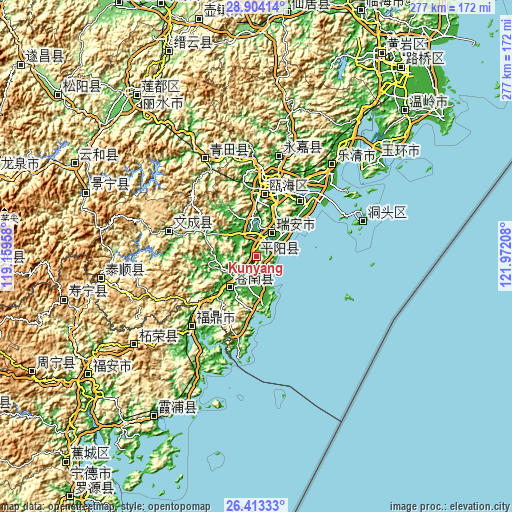
| \ | Map #1 | Map #2 | Topo.Map |
| Scale [m] | 0..509 m | -3..646 m | × |
| Scale [ft] | 0..1670 ft | -10..2119 ft | × |
| Average | 78 m = 256 ft | 103.3 m = 339 ft | × |
| Width | 8.66 km = 5.4 mi | 17.31 km = 10.8 mi | 277 km = 172.1 mi |
| Height | 8.66 km = 5.4 mi | 17.31 km = 10.8 mi | 277 km = 172.1 mi |
| ↑Max Latitude | 27.704744° | 27.743644° | 28.90414° |
| Latitude at center | 27.66583° | 27.66583° | 27.66583° |
| ↓Min Latitude | 27.626902° | 27.58796° | 26.41333° |
| ← Min Longitude | 120.521885° | 120.477939° | 119.15958° |
| Longitude center | 120.56583° | 120.56583° | 120.56583° |
| →Max Longitude | 120.609775° | 120.653721° | 121.97208° |
Nearby cities:
Cities around Kunyang sort by population:
• Wenzhou elevation 10 m
38.4 km,  14°
14°
• Jinxiang 10 m
26.2 km,  171°
171°
• Fuding 13 m
51.2 km,  222°
222°
• Chongru 247 m
101.6 km, 218°
• Luoyang 516 m
85 km,  262°
262°
• Zhugang 13 m
83.5 km,  51°
51°
• Zherong 666 m
81.4 km,  234°
234°
• Hecheng 20 m
59.3 km,  332°
332°
• Shangtang 16 m
55.7 km, 12°
• Wuma 13 m
40.3 km, 14°
• Louqiao 13 m
38.9 km, 9°
• Shiqiao 10 m
35.2 km,  358°
358°
Multilingual:
 En español:
Kunyang elevación 146 m.
 En France:
Kunyang élévation 146 m.


Sources and notes:
- [note 1] Map square and city borders are not equal. Map elevation data is calculated only from area inside that square.
- [src 1] Elevation data from geonames database provided with same terms of usage.
- [src 2] The elevation map of Kunyang is generated using elevation data from NASA's 3 arcsec (90m) resolution SRTM data.
- [src 3] Base (background) map © OpenStreetMap contributors tiles are generated by Geofabrik and OpenTopoMap.
Copyright & License:
This Kunyang Elevation Map is licensed under CC BY-SA. You may reuse any part from this page, if you give a proper credit by linking to this URL:
 More info on terms of use page.