Xiayang elevation
Xiayang (Hunan), China elevation is 217 meters and Xiayang elevation in feet is 712 ft above sea level [src 1]. Xiayang is a seat of a third-order administrative division (feature code) with elevation that is 341 meters (1119 ft) smaller than average city elevation in China.
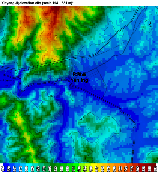
Below is the Elevation map of Xiayang, which displays elevation range with different colors. Scale of the first map is from 194 to 881 m (636 to 2890 ft) with average elevation of 342.6 meters (=1124 ft) [note 1]
These maps also provides idea of topography and contour of this city, they are displayed at different zoom levels. More info about maps, scale and edge coordinates you can find below images.
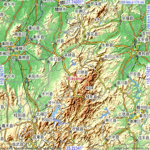
| \ | Map #1 | Topo.Map |
| Scale [m] | 194..881 m | × |
| Scale [ft] | 636..2890 ft | × |
| Average | 342.6 m = 1124 ft | × |
| Width | 8.75 km = 5.4 mi | 279.9 km = 173.9 mi |
| Height | 8.75 km = 5.4 mi | 279.9 km = 173.9 mi |
| ↑Max Latitude | 26.528175° | 27.74051° |
| Latitude at center | 26.48885° | 26.48885° |
| ↓Min Latitude | 26.449511° | 25.22341° |
| ← Min Longitude | 113.724015° | 112.36171° |
| Longitude center | 113.76796° | 113.76796° |
| →Max Longitude | 113.811905° | 115.17421° |
Nearby cities:
Cities around Xiayang sort by population:
• Leiyang elevation 69 m
91 km,  263°
263°
• Furong 139 m
99.5 km,  92°
92°
• Quanjiang 99 m
76.8 km,  105°
105°
• Yongxing Chengguanzhen 127 m
75.5 km,  237°
237°
• Tangdong 131 m
74.6 km,  223°
223°
• Qinting 170 m
72.9 km,  14°
14°
• Youxian Chengguanzhen 84 m
69 km,  324°
324°
• Hechuan 120 m
67.5 km,  42°
42°
• Xiaping 253 m
56.8 km,  61°
61°
• Anren Chengguanzhen 110 m
55.7 km,  296°
296°
• Guidong Chengguanzhen 826 m
48.7 km,  159°
159°
• Chaling Chengguanzhen 133 m
40.5 km,  325°
325°
Multilingual:
 En español:
Xiayang elevación 217 m.
 En France:
Xiayang élévation 217 m.


Sources and notes:
- [note 1] Map square and city borders are not equal. Map elevation data is calculated only from area inside that square.
- [src 1] Elevation data from geonames database provided with same terms of usage.
- [src 2] The elevation map of Xiayang is generated using elevation data from NASA's 3 arcsec (90m) resolution SRTM data.
- [src 3] Base (background) map © OpenStreetMap contributors tiles are generated by Geofabrik and OpenTopoMap.
Copyright & License:
This Xiayang Elevation Map is licensed under CC BY-SA. You may reuse any part from this page, if you give a proper credit by linking to this URL:
 More info on terms of use page.