Longtan elevation
Longtan (Hunan), China elevation is 490 meters and Longtan elevation in feet is 1608 ft above sea level [src 1]. Longtan is a populated place (feature code) with elevation that is 68 meters (223 ft) smaller than average city elevation in China.
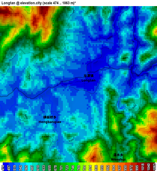
Below is the Elevation map of Longtan, which displays elevation range with different colors. Scale of the first map is from 474 to 1063 m (1555 to 3488 ft) with average elevation of 609.4 meters (=1999 ft) [note 1]
These maps also provides idea of topography and contour of this city, they are displayed at different zoom levels. More info about maps, scale and edge coordinates you can find below images.
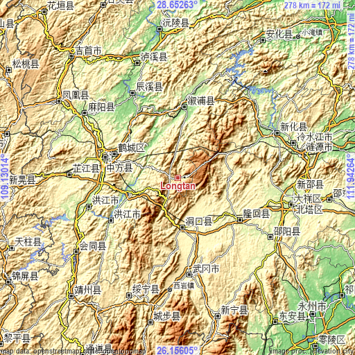
| \ | Map #1 | Topo.Map |
| Scale [m] | 474..1063 m | × |
| Scale [ft] | 1555..3488 ft | × |
| Average | 609.4 m = 1999 ft | × |
| Width | 8.68 km = 5.4 mi | 277.6 km = 172.5 mi |
| Height | 8.68 km = 5.4 mi | 277.6 km = 172.5 mi |
| ↑Max Latitude | 27.450394° | 28.65263° |
| Latitude at center | 27.41139° | 27.41139° |
| ↓Min Latitude | 27.372372° | 26.15605° |
| ← Min Longitude | 110.492445° | 109.13014° |
| Longitude center | 110.53639° | 110.53639° |
| →Max Longitude | 110.580335° | 111.94264° |
Nearby cities:
Cities around Longtan sort by population:
• Liuduzhai elevation 311 m
39.7 km,  97°
97°
• Simenqian 376 m
35.5 km,  76°
76°
• Shanmen 348 m
25.8 km,  143°
143°
• Longtou’an 150 m
34.9 km,  325°
325°
• Tongwan 174 m
31.8 km,  306°
306°
• Xiaoshajiang 1333 m
24.2 km,  59°
59°
• Zhushi 289 m
38.6 km,  158°
158°
• Huangmaoyuan 561 m
6.1 km,  262°
262°
• Huangxikou 134 m
37.3 km,  336°
336°
• Xiaohenglong 570 m
21.6 km,  354°
354°
• Liangyaping 284 m
36.6 km,  21°
21°
• Dongkou 403 m
39.9 km,  180°
180°
Multilingual:
 En español:
Longtan elevación 490 m.
 En France:
Longtan élévation 490 m.


Sources and notes:
- [note 1] Map square and city borders are not equal. Map elevation data is calculated only from area inside that square.
- [src 1] Elevation data from geonames database provided with same terms of usage.
- [src 2] The elevation map of Longtan is generated using elevation data from NASA's 3 arcsec (90m) resolution SRTM data.
- [src 3] Base (background) map © OpenStreetMap contributors tiles are generated by Geofabrik and OpenTopoMap.
Copyright & License:
This Longtan Elevation Map is licensed under CC BY-SA. You may reuse any part from this page, if you give a proper credit by linking to this URL:
 More info on terms of use page.