Loudi elevation
Loudi (Hunan, Loudi Shi), China elevation is 135 meters and Loudi elevation in feet is 443 ft above sea level [src 1]. Loudi is a populated place (feature code) with elevation that is 423 meters (1388 ft) smaller than average city elevation in China.
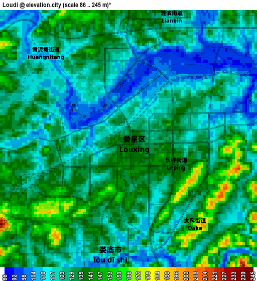
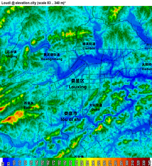
Below is the Elevation map of Loudi, which displays elevation range with different colors. Scale of the first map is from 86 to 245 m (282 to 804 ft) with average elevation of 127.4 meters (=418 ft) [note 1]
These maps also provides idea of topography and contour of this city, they are displayed at different zoom levels. More info about maps, scale and edge coordinates you can find below images.
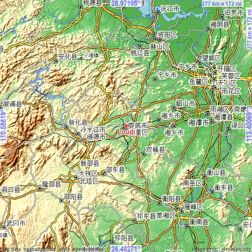
| \ | Map #1 | Map #2 | Topo.Map |
| Scale [m] | 86..245 m | 83..340 m | × |
| Scale [ft] | 282..804 ft | 272..1115 ft | × |
| Average | 127.4 m = 418 ft | 136.4 m = 448 ft | × |
| Width | 8.65 km = 5.4 mi | 17.3 km = 10.7 mi | 276.8 km = 172 mi |
| Height | 8.65 km = 5.4 mi | 17.3 km = 10.7 mi | 276.8 km = 172 mi |
| ↑Max Latitude | 27.77333° | 27.812205° | 28.97195° |
| Latitude at center | 27.73444° | 27.73444° | 27.73444° |
| ↓Min Latitude | 27.695536° | 27.656619° | 26.48271° |
| ← Min Longitude | 111.950495° | 111.906549° | 110.58819° |
| Longitude center | 111.99444° | 111.99444° | 111.99444° |
| →Max Longitude | 112.038385° | 112.082331° | 113.40069° |
Nearby cities:
Cities around Loudi sort by population:
• Xiangtan elevation 31 m
90 km,  81°
81°
• Lengshuijiang 194 m
55.9 km,  264°
264°
• Xiangxiang 46 m
53 km,  90°
90°
• Shangmei 179 m
68.8 km,  270°
270°
• Yongfeng 118 m
38.8 km,  151°
151°
• Lianyuan 151 m
32.9 km, 261°
• Yutan 53 m
80.5 km,  43°
43°
• Xidu 67 m
94.1 km,  156°
156°
• Yisuhe 39 m
91.8 km, 87°
• Taohuajiang 45 m
88.7 km,  8°
8°
• Niangxi 246 m
72.9 km,  229°
229°
• Liangshi 274 m
64 km,  203°
203°
Multilingual:
 En español:
Loudi elevación 135 m.
 En France:
Loudi élévation 135 m.


Sources and notes:
- [note 1] Map square and city borders are not equal. Map elevation data is calculated only from area inside that square.
- [src 1] Elevation data from geonames database provided with same terms of usage.
- [src 2] The elevation map of Loudi is generated using elevation data from NASA's 3 arcsec (90m) resolution SRTM data.
- [src 3] Base (background) map © OpenStreetMap contributors tiles are generated by Geofabrik and OpenTopoMap.
Copyright & License:
This Loudi Elevation Map is licensed under CC BY-SA. You may reuse any part from this page, if you give a proper credit by linking to this URL:
 More info on terms of use page.