Niangxi elevation
Niangxi (Hunan), China elevation is 246 meters and Niangxi elevation in feet is 807 ft above sea level [src 1]. Niangxi is a seat of a third-order administrative division (feature code) with elevation that is 312 meters (1024 ft) smaller than average city elevation in China.
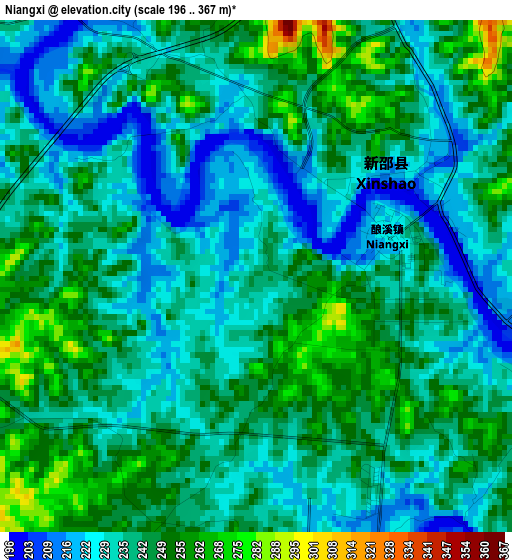
Below is the Elevation map of Niangxi, which displays elevation range with different colors. Scale of the first map is from 196 to 367 m (643 to 1204 ft) with average elevation of 239.3 meters (=785 ft) [note 1]
These maps also provides idea of topography and contour of this city, they are displayed at different zoom levels. More info about maps, scale and edge coordinates you can find below images.
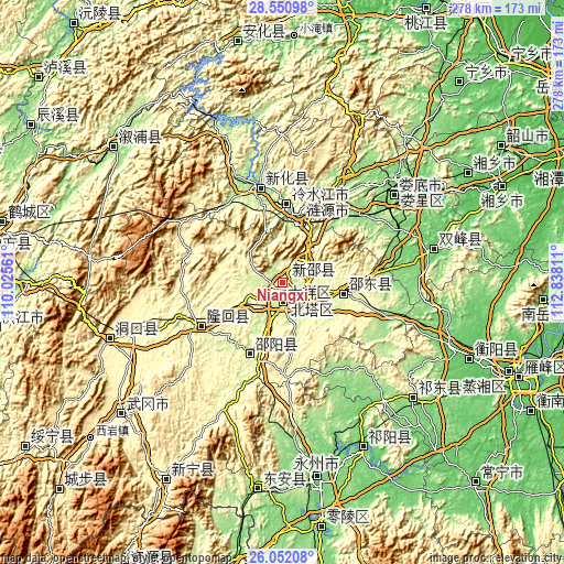
| \ | Map #1 | Topo.Map |
| Scale [m] | 196..367 m | × |
| Scale [ft] | 643..1204 ft | × |
| Average | 239.3 m = 785 ft | × |
| Width | 8.68 km = 5.4 mi | 277.9 km = 172.7 mi |
| Height | 8.68 km = 5.4 mi | 277.9 km = 172.7 mi |
| ↑Max Latitude | 27.347601° | 28.55098° |
| Latitude at center | 27.30856° | 27.30856° |
| ↓Min Latitude | 27.269506° | 26.05208° |
| ← Min Longitude | 111.387915° | 110.02561° |
| Longitude center | 111.43186° | 111.43186° |
| →Max Longitude | 111.475805° | 112.83811° |
Nearby cities:
Cities around Niangxi sort by population:
• Lengshuijiang elevation 194 m
42.2 km,  359°
359°
• Shangmei 179 m
50.1 km,  344°
344°
• Lianyuan 151 m
48 km,  28°
28°
• Liuduzhai 311 m
49.5 km,  277°
277°
• Simenqian 376 m
57.4 km,  290°
290°
• Hexiangqiao 278 m
47.3 km,  258°
258°
• Shuiche 447 m
59.9 km,  314°
314°
• Jinshiqiao 470 m
57.7 km,  302°
302°
• Hengbanqiao 294 m
58 km,  254°
254°
• Taohong 276 m
49 km,  241°
241°
• Tangdukou 323 m
42.5 km,  206°
206°
• Liangshi 274 m
32.2 km,  110°
110°
Multilingual:
 En español:
Niangxi elevación 246 m.
 En France:
Niangxi élévation 246 m.


Sources and notes:
- [note 1] Map square and city borders are not equal. Map elevation data is calculated only from area inside that square.
- [src 1] Elevation data from geonames database provided with same terms of usage.
- [src 2] The elevation map of Niangxi is generated using elevation data from NASA's 3 arcsec (90m) resolution SRTM data.
- [src 3] Base (background) map © OpenStreetMap contributors tiles are generated by Geofabrik and OpenTopoMap.
Copyright & License:
This Niangxi Elevation Map is licensed under CC BY-SA. You may reuse any part from this page, if you give a proper credit by linking to this URL:
 More info on terms of use page.