Mingfeng elevation
Mingfeng (Hubei), China elevation is 110 meters and Mingfeng elevation in feet is 361 ft above sea level [src 1]. Mingfeng is a seat of a third-order administrative division (feature code) with elevation that is 448 meters (1470 ft) smaller than average city elevation in China.
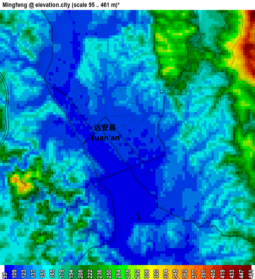
Below is the Elevation map of Mingfeng, which displays elevation range with different colors. Scale of the first map is from 95 to 461 m (312 to 1512 ft) with average elevation of 158.1 meters (=519 ft) [note 1]
These maps also provides idea of topography and contour of this city, they are displayed at different zoom levels. More info about maps, scale and edge coordinates you can find below images.
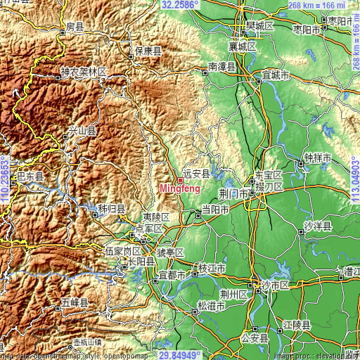
| \ | Map #1 | Topo.Map |
| Scale [m] | 95..461 m | × |
| Scale [ft] | 312..1512 ft | × |
| Average | 158.1 m = 519 ft | × |
| Width | 8.37 km = 5.2 mi | 267.9 km = 166.5 mi |
| Height | 8.37 km = 5.2 mi | 267.9 km = 166.5 mi |
| ↑Max Latitude | 31.099307° | 32.2586° |
| Latitude at center | 31.06167° | 31.06167° |
| ↓Min Latitude | 31.024018° | 29.84949° |
| ← Min Longitude | 111.598835° | 110.23653° |
| Longitude center | 111.64278° | 111.64278° |
| →Max Longitude | 111.686725° | 113.04903° |
Nearby cities:
Cities around Mingfeng sort by population:
• Yichang elevation 63 m
51.6 km,  221°
221°
• Jingmen 94 m
53.6 km,  93°
93°
• Zhicheng 51 m
86.2 km,  188°
188°
• Zhongxiang 50 m
90.3 km,  82°
82°
• Nanzhang Chengguanzhen 130 m
82.2 km,  12°
12°
• Yicheng 63 m
92.2 km,  39°
39°
• Zhijiang 46 m
72 km,  171°
171°
• Maoping 229 m
68.5 km,  247°
247°
• Gulaobei 58 m
63.7 km,  198°
198°
• Dianjun 75 m
54.2 km, 222°
• Xiling 63 m
51.5 km, 221°
• Xiaoxita 75 m
44.5 km, 223°
Multilingual:
 En español:
Mingfeng elevación 110 m.
 En France:
Mingfeng élévation 110 m.
 Auf Deutsch:
Mingfeng höhe über dem Meeresspiegel ist 110 m.

Sources and notes:
- [note 1] Map square and city borders are not equal. Map elevation data is calculated only from area inside that square.
- [src 1] Elevation data from geonames database provided with same terms of usage.
- [src 2] The elevation map of Mingfeng is generated using elevation data from NASA's 3 arcsec (90m) resolution SRTM data.
- [src 3] Base (background) map © OpenStreetMap contributors tiles are generated by Geofabrik and OpenTopoMap.
Copyright & License:
This Mingfeng Elevation Map is licensed under CC BY-SA. You may reuse any part from this page, if you give a proper credit by linking to this URL:
 More info on terms of use page.