Yichang elevation
Yichang (Hubei, Yichangshi), China elevation is 63 meters and Yichang elevation in feet is 207 ft above sea level [src 1]. Yichang is a populated place (feature code) with elevation that is 495 meters (1624 ft) smaller than average city elevation in China.
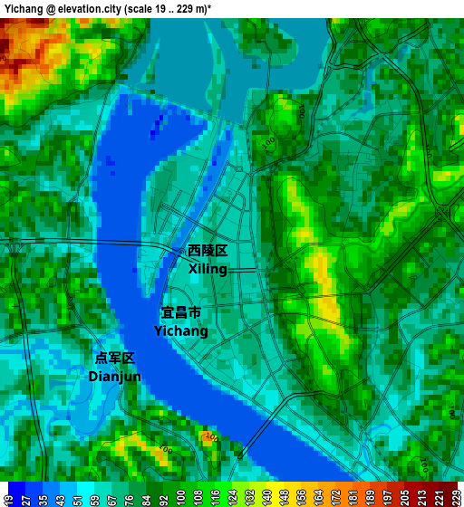
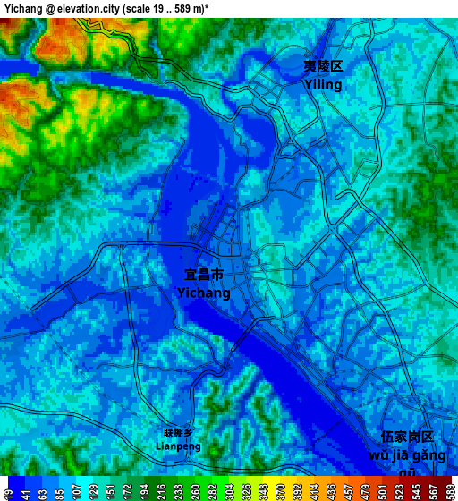
Below is the Elevation map of Yichang, which displays elevation range with different colors. Scale of the first map is from 19 to 229 m (62 to 751 ft) with average elevation of 78.2 meters (=257 ft) [note 1]
These maps also provides idea of topography and contour of this city, they are displayed at different zoom levels. More info about maps, scale and edge coordinates you can find below images.
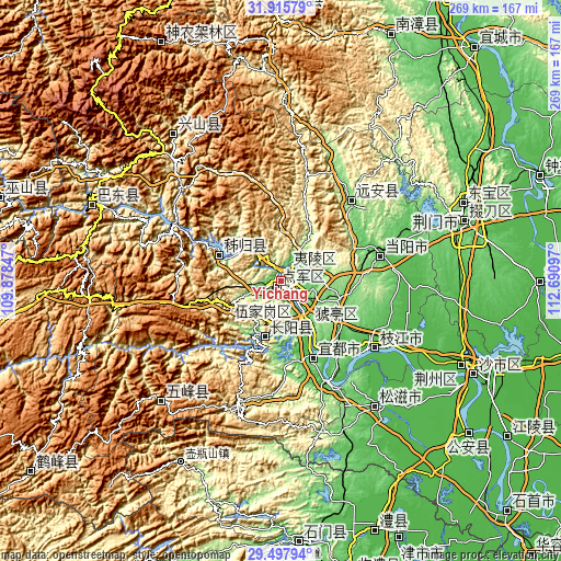
| \ | Map #1 | Map #2 | Topo.Map |
| Scale [m] | 19..229 m | 19..589 m | × |
| Scale [ft] | 62..751 ft | 62..1932 ft | × |
| Average | 78.2 m = 257 ft | 121.5 m = 399 ft | × |
| Width | 8.4 km = 5.2 mi | 16.8 km = 10.4 mi | 268.8 km = 167 mi |
| Height | 8.4 km = 5.2 mi | 16.8 km = 10.4 mi | 268.8 km = 167 mi |
| ↑Max Latitude | 30.752213° | 30.789972° | 31.91579° |
| Latitude at center | 30.71444° | 30.71444° | 30.71444° |
| ↓Min Latitude | 30.676652° | 30.638849° | 29.49794° |
| ← Min Longitude | 111.240775° | 111.196829° | 109.87847° |
| Longitude center | 111.28472° | 111.28472° | 111.28472° |
| →Max Longitude | 111.328665° | 111.372611° | 112.69097° |
Nearby cities:
Cities around Yichang sort by population:
• Jingzhou elevation 39 m
95.7 km,  115°
115°
• Jingmen 94 m
94.7 km,  67°
67°
• Zhicheng 51 m
51.1 km,  155°
155°
• Zhijiang 46 m
55.4 km,  125°
125°
• Gufu 918 m
89.4 km,  323°
323°
• Wufeng 760 m
80.7 km,  224°
224°
• Mingfeng 110 m
51.6 km,  41°
41°
• Maoping 229 m
32 km,  293°
293°
• Gulaobei 58 m
25.6 km,  147°
147°
• Xiaoxita 75 m
7.2 km,  29°
29°
• Dianjun 75 m
2.8 km,  238°
238°
• Xiling 63 m
0.2 km,  336°
336°
Multilingual:
 En español:
Yichang elevación 63 m.
 En France:
Yichang élévation 63 m.


Sources and notes:
- [note 1] Map square and city borders are not equal. Map elevation data is calculated only from area inside that square.
- [src 1] Elevation data from geonames database provided with same terms of usage.
- [src 2] The elevation map of Yichang is generated using elevation data from NASA's 3 arcsec (90m) resolution SRTM data.
- [src 3] Base (background) map © OpenStreetMap contributors tiles are generated by Geofabrik and OpenTopoMap.
Copyright & License:
This Yichang Elevation Map is licensed under CC BY-SA. You may reuse any part from this page, if you give a proper credit by linking to this URL:
 More info on terms of use page.