Pingxiang elevation
Pingxiang (Jiangxi, Pingxiang Shi), China elevation is 167 meters and Pingxiang elevation in feet is 548 ft above sea level [src 1]. Pingxiang is a seat of a second-order administrative division (feature code) with elevation that is 391 meters (1283 ft) smaller than average city elevation in China.
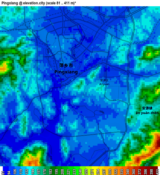
Below is the Elevation map of Pingxiang, which displays elevation range with different colors. Scale of the first map is from 81 to 411 m (266 to 1348 ft) with average elevation of 127.6 meters (=419 ft) [note 1]
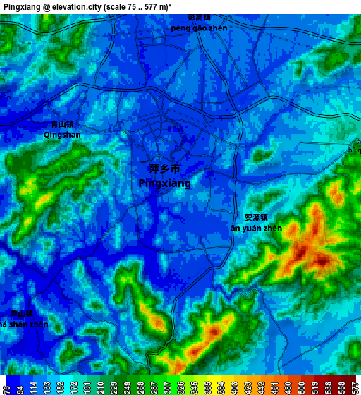
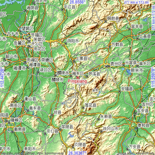
These maps also provides idea of topography and contour of this city, they are displayed at different zoom levels. More info about maps, scale and edge coordinates you can find below images.
| \ | Map #1 | Map #2 | Topo.Map |
| Scale [m] | 81..411 m | 75..577 m | × |
| Scale [ft] | 266..1348 ft | 246..1893 ft | × |
| Average | 127.6 m = 419 ft | 163.2 m = 535 ft | × |
| Width | 8.66 km = 5.4 mi | 17.32 km = 10.8 mi | 277.1 km = 172.2 mi |
| Height | 8.66 km = 5.4 mi | 17.32 km = 10.8 mi | 277.1 km = 172.2 mi |
| ↑Max Latitude | 27.655652° | 27.694569° | 28.8556° |
| Latitude at center | 27.61672° | 27.61672° | 27.61672° |
| ↓Min Latitude | 27.577775° | 27.538815° | 26.36367° |
| ← Min Longitude | 113.809585° | 113.765639° | 112.44728° |
| Longitude center | 113.85353° | 113.85353° | 113.85353° |
| →Max Longitude | 113.897475° | 113.941421° | 115.25978° |
Nearby cities:
Cities around Pingxiang sort by population:
• Guankou elevation 79 m
64.2 km,  339°
339°
• Zhuzhou 54 m
73.3 km,  289°
289°
• Yichun 99 m
58.9 km,  65°
65°
• Xishan 69 m
35.3 km,  279°
279°
• Kangle 92 m
79.2 km,  47°
47°
• Pingdu 90 m
78.9 km,  108°
108°
• Lukou 40 m
69.7 km, 277°
• Qinting 170 m
55.6 km,  170°
170°
• Yuanzhou 102 m
55.3 km, 68°
• Shangli 90 m
29.6 km,  348°
348°
• Luxi 143 m
18 km,  83°
83°
• Xiangdong 80 m
13.3 km, 287°
Multilingual:
 En español:
Pingxiang elevación 167 m.
 En France:
Pingxiang élévation 167 m.
 Auf Deutsch:
Pingxiang höhe über dem Meeresspiegel ist 167 m.

Sources and notes:
- [note 1] Map square and city borders are not equal. Map elevation data is calculated only from area inside that square.
- [src 1] Elevation data from geonames database provided with same terms of usage.
- [src 2] The elevation map of Pingxiang is generated using elevation data from NASA's 3 arcsec (90m) resolution SRTM data.
- [src 3] Base (background) map © OpenStreetMap contributors tiles are generated by Geofabrik and OpenTopoMap.
Copyright & License:
This Pingxiang Elevation Map is licensed under CC BY-SA. You may reuse any part from this page, if you give a proper credit by linking to this URL:
 More info on terms of use page.