Yichun elevation
Yichun (Jiangxi), China elevation is 99 meters and Yichun elevation in feet is 325 ft above sea level [src 1]. Yichun is a seat of a second-order administrative division (feature code) with elevation that is 459 meters (1506 ft) smaller than average city elevation in China.
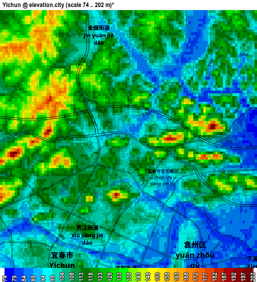
Below is the Elevation map of Yichun, which displays elevation range with different colors. Scale of the first map is from 74 to 202 m (243 to 663 ft) with average elevation of 110.4 meters (=362 ft) [note 1]
These maps also provides idea of topography and contour of this city, they are displayed at different zoom levels. More info about maps, scale and edge coordinates you can find below images.

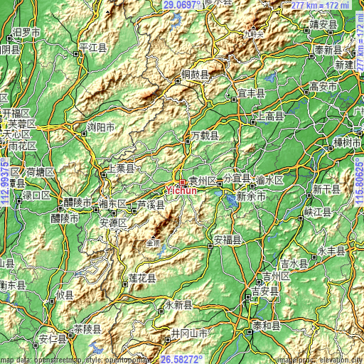
| \ | Map #1 | Map #2 | Topo.Map |
| Scale [m] | 74..202 m | 52..363 m | × |
| Scale [ft] | 243..663 ft | 171..1191 ft | × |
| Average | 110.4 m = 362 ft | 120.7 m = 396 ft | × |
| Width | 8.64 km = 5.4 mi | 17.28 km = 10.7 mi | 276.5 km = 171.8 mi |
| Height | 8.64 km = 5.4 mi | 17.28 km = 10.7 mi | 276.5 km = 171.8 mi |
| ↑Max Latitude | 27.872184° | 27.911025° | 29.0697° |
| Latitude at center | 27.83333° | 27.83333° | 27.83333° |
| ↓Min Latitude | 27.794462° | 27.75558° | 26.58272° |
| ← Min Longitude | 114.356055° | 114.312109° | 112.99375° |
| Longitude center | 114.4° | 114.4° | 114.4° |
| →Max Longitude | 114.443945° | 114.487891° | 115.80625° |
Nearby cities:
Cities around Yichun sort by population:
• Pingxiang elevation 167 m
58.9 km,  245°
245°
• Xinyu 68 m
52.5 km,  93°
93°
• Fenyi 84 m
26.5 km,  95°
95°
• Yongning 233 m
76.9 km,  357°
357°
• Xiangdong 80 m
69.5 km, 253°
• Aoyang 54 m
68.2 km,  48°
48°
• Shangli 90 m
60 km,  274°
274°
• Pingdu 90 m
53.8 km,  157°
157°
• Xinyu 120 m
43.8 km, 89°
• Luxi 143 m
42.1 km,  238°
238°
• Kangle 92 m
29.6 km,  9°
9°
• Yuanzhou 102 m
4.5 km,  211°
211°
Multilingual:
 En español:
Yichun elevación 99 m.
 En France:
Yichun élévation 99 m.


Sources and notes:
- [note 1] Map square and city borders are not equal. Map elevation data is calculated only from area inside that square.
- [src 1] Elevation data from geonames database provided with same terms of usage.
- [src 2] The elevation map of Yichun is generated using elevation data from NASA's 3 arcsec (90m) resolution SRTM data.
- [src 3] Base (background) map © OpenStreetMap contributors tiles are generated by Geofabrik and OpenTopoMap.
Copyright & License:
This Yichun Elevation Map is licensed under CC BY-SA. You may reuse any part from this page, if you give a proper credit by linking to this URL:
 More info on terms of use page.