Gutao elevation
Gutao (Shanxi), China elevation is 763 meters and Gutao elevation in feet is 2503 ft above sea level [src 1]. Gutao is a seat of a third-order administrative division (feature code) with elevation that is 205 meters (673 ft) bigger than average city elevation in China.
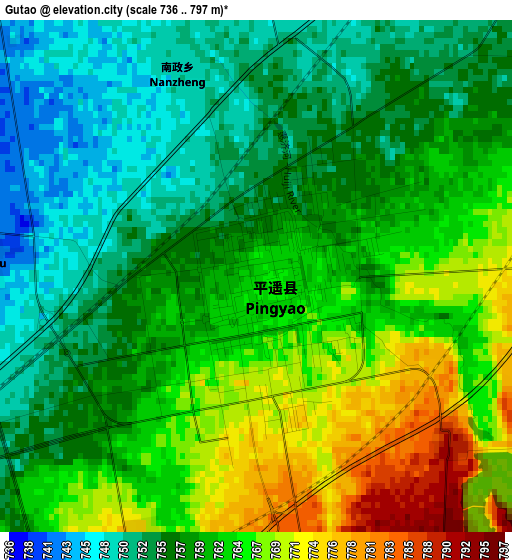
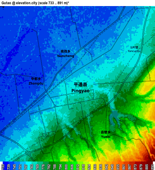
Below is the Elevation map of Gutao, which displays elevation range with different colors. Scale of the first map is from 736 to 797 m (2415 to 2615 ft) with average elevation of 760.1 meters (=2494 ft) [note 1]
These maps also provides idea of topography and contour of this city, they are displayed at different zoom levels. More info about maps, scale and edge coordinates you can find below images.
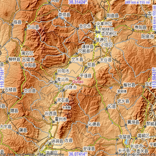
| \ | Map #1 | Map #2 | Topo.Map |
| Scale [m] | 736..797 m | 733..891 m | × |
| Scale [ft] | 2415..2615 ft | 2405..2923 ft | × |
| Average | 760.1 m = 2494 ft | 767.2 m = 2517 ft | × |
| Width | 7.78 km = 4.8 mi | 15.57 km = 9.7 mi | 249.1 km = 154.8 mi |
| Height | 7.78 km = 4.8 mi | 15.57 km = 9.7 mi | 249.1 km = 154.8 mi |
| ↑Max Latitude | 37.237494° | 37.272473° | 38.31424° |
| Latitude at center | 37.2025° | 37.2025° | 37.2025° |
| ↓Min Latitude | 37.167489° | 37.132462° | 36.07414° |
| ← Min Longitude | 112.134115° | 112.090169° | 110.77181° |
| Longitude center | 112.17806° | 112.17806° | 112.17806° |
| →Max Longitude | 112.222005° | 112.265951° | 113.58431° |
Nearby cities:
Cities around Gutao sort by population:
• Jiexiu elevation 756 m
30.8 km,  229°
229°
• Fengzhou 952 m
72.1 km,  123°
123°
• Jicheng 994 m
70.8 km,  102°
102°
• Xiaodian 775 m
68.1 km,  29°
29°
• Dingchang 957 m
66.6 km,  137°
137°
• Jinyuan 779 m
63.8 km,  23°
23°
• Cuifeng 811 m
53.1 km,  221°
221°
• Qingyuan 784 m
48 km, 15°
• Mingxing 788 m
40.8 km,  52°
52°
• Tianning 762 m
38.4 km,  357°
357°
• Fengcheng 760 m
29 km,  331°
331°
• Zhaoyu 766 m
21 km,  35°
35°
Multilingual:
 En español:
Pingyao elevación 763 m.
 En France:
Xian de Pingyao élévation 763 m.


Sources and notes:
- [note 1] Map square and city borders are not equal. Map elevation data is calculated only from area inside that square.
- [src 1] Elevation data from geonames database provided with same terms of usage.
- [src 2] The elevation map of Gutao is generated using elevation data from NASA's 3 arcsec (90m) resolution SRTM data.
- [src 3] Base (background) map © OpenStreetMap contributors tiles are generated by Geofabrik and OpenTopoMap.
Copyright & License:
This Gutao Elevation Map is licensed under CC BY-SA. You may reuse any part from this page, if you give a proper credit by linking to this URL:
 More info on terms of use page.