Jicheng elevation
Jicheng (Shanxi), China elevation is 994 meters and Jicheng elevation in feet is 3261 ft above sea level [src 1]. Jicheng is a seat of a third-order administrative division (feature code) with elevation that is 436 meters (1430 ft) bigger than average city elevation in China.
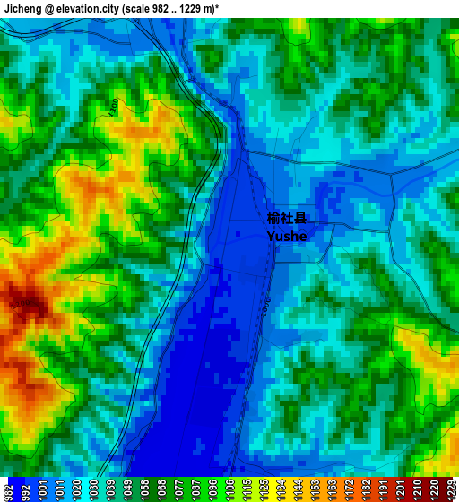
Below is the Elevation map of Jicheng, which displays elevation range with different colors. Scale of the first map is from 982 to 1229 m (3222 to 4032 ft) with average elevation of 1050.7 meters (=3447 ft) [note 1]
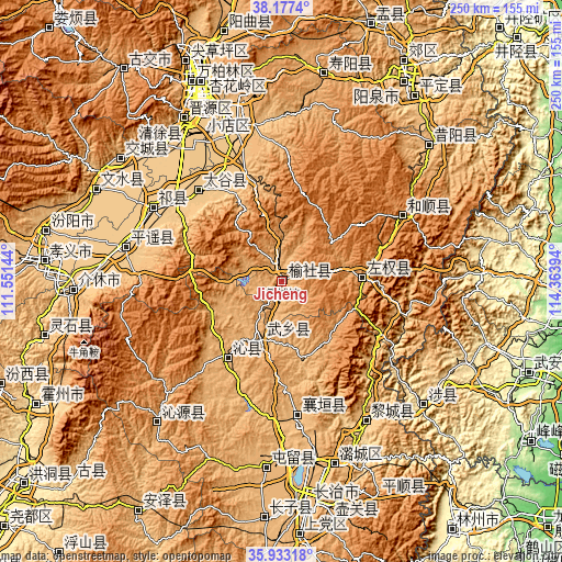
These maps also provides idea of topography and contour of this city, they are displayed at different zoom levels. More info about maps, scale and edge coordinates you can find below images.
| \ | Map #1 | Topo.Map |
| Scale [m] | 982..1229 m | × |
| Scale [ft] | 3222..4032 ft | × |
| Average | 1050.7 m = 3447 ft | × |
| Width | 7.8 km = 4.8 mi | 249.5 km = 155 mi |
| Height | 7.8 km = 4.8 mi | 249.5 km = 155 mi |
| ↑Max Latitude | 37.098649° | 38.1774° |
| Latitude at center | 37.06359° | 37.06359° |
| ↓Min Latitude | 37.028515° | 35.93318° |
| ← Min Longitude | 112.913745° | 111.55144° |
| Longitude center | 112.95769° | 112.95769° |
| →Max Longitude | 113.001635° | 114.36394° |
Nearby cities:
Cities around Jicheng sort by population:
• Yuci elevation 798 m
71.4 km,  343°
343°
• Gutao 763 m
70.8 km,  282°
282°
• Xiaodian 775 m
82.8 km,  334°
334°
• Linjiang 920 m
82.1 km,  184°
184°
• Lihou 747 m
72.3 km,  149°
149°
• Zhaoyu 766 m
65.4 km,  299°
299°
• Yixing 1379 m
59.8 km,  59°
59°
• Guhan 890 m
59 km,  174°
174°
• Mingxing 788 m
54.5 km,  317°
317°
• Dingchang 957 m
41.2 km,  215°
215°
• Liaoyang 1139 m
34 km,  86°
86°
• Fengzhou 952 m
26.2 km,  200°
200°
Multilingual:
 En español:
Jicheng elevación 994 m.
 En France:
Jicheng élévation 994 m.


Sources and notes:
- [note 1] Map square and city borders are not equal. Map elevation data is calculated only from area inside that square.
- [src 1] Elevation data from geonames database provided with same terms of usage.
- [src 2] The elevation map of Jicheng is generated using elevation data from NASA's 3 arcsec (90m) resolution SRTM data.
- [src 3] Base (background) map © OpenStreetMap contributors tiles are generated by Geofabrik and OpenTopoMap.
Copyright & License:
This Jicheng Elevation Map is licensed under CC BY-SA. You may reuse any part from this page, if you give a proper credit by linking to this URL:
 More info on terms of use page.