Binhe elevation
Binhe (Henan), China elevation is 109 meters and Binhe elevation in feet is 358 ft above sea level [src 1]. Binhe is a seat of a third-order administrative division (feature code) with elevation that is 449 meters (1473 ft) smaller than average city elevation in China.
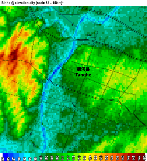
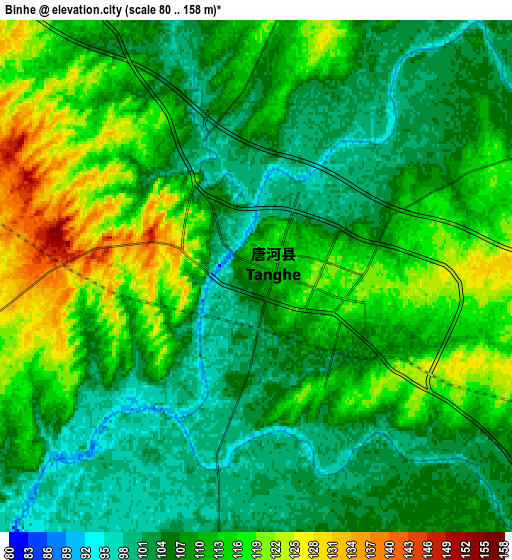
Below is the Elevation map of Binhe, which displays elevation range with different colors. Scale of the first map is from 82 to 150 m (269 to 492 ft) with average elevation of 107.7 meters (=353 ft) [note 1]
These maps also provides idea of topography and contour of this city, they are displayed at different zoom levels. More info about maps, scale and edge coordinates you can find below images.
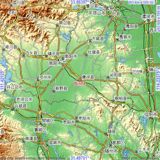
| \ | Map #1 | Map #2 | Topo.Map |
| Scale [m] | 82..150 m | 80..158 m | × |
| Scale [ft] | 269..492 ft | 262..518 ft | × |
| Average | 107.7 m = 353 ft | 109.5 m = 359 ft | × |
| Width | 8.22 km = 5.1 mi | 16.45 km = 10.2 mi | 263.2 km = 163.5 mi |
| Height | 8.22 km = 5.1 mi | 16.45 km = 10.2 mi | 263.2 km = 163.5 mi |
| ↑Max Latitude | 32.725308° | 32.76227° | 33.86397° |
| Latitude at center | 32.68833° | 32.68833° | 32.68833° |
| ↓Min Latitude | 32.651337° | 32.614329° | 31.49701° |
| ← Min Longitude | 112.783555° | 112.739609° | 111.42125° |
| Longitude center | 112.8275° | 112.8275° | 112.8275° |
| →Max Longitude | 112.871445° | 112.915391° | 114.23375° |
Nearby cities:
Cities around Binhe sort by population:
• Nanyang elevation 131 m
43.8 km,  321°
321°
• Zaoyang 113 m
62.8 km,  186°
186°
• Yunyang 202 m
85.1 km,  352°
352°
• Hancheng 94 m
48.4 km,  247°
247°
• Huazhou 119 m
69.8 km,  269°
269°
• Yakou 143 m
93.7 km,  43°
43°
• Zhangwan 70 m
91.5 km,  222°
222°
• Zhenping Chengguanzhen 189 m
67.5 km,  304°
304°
• Fangcheng Chengguanzhen 158 m
64.9 km,  14°
14°
• Tongbai Chengguanzhen 148 m
64.4 km,  124°
124°
• Bishui 142 m
45.4 km,  85°
85°
• Shedian 122 m
42.8 km, 14°
Multilingual:
 En español:
Binhe elevación 109 m.
 En France:
Binhe élévation 109 m.


Sources and notes:
- [note 1] Map square and city borders are not equal. Map elevation data is calculated only from area inside that square.
- [src 1] Elevation data from geonames database provided with same terms of usage.
- [src 2] The elevation map of Binhe is generated using elevation data from NASA's 3 arcsec (90m) resolution SRTM data.
- [src 3] Base (background) map © OpenStreetMap contributors tiles are generated by Geofabrik and OpenTopoMap.
Copyright & License:
This Binhe Elevation Map is licensed under CC BY-SA. You may reuse any part from this page, if you give a proper credit by linking to this URL:
 More info on terms of use page.