Tongren elevation
Tongren (Guizhou, Tongren Diqu), China elevation is 263 meters and Tongren elevation in feet is 863 ft above sea level [src 1]. Tongren is a populated place (feature code) with elevation that is 295 meters (968 ft) smaller than average city elevation in China.
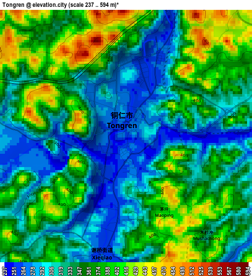
Below is the Elevation map of Tongren, which displays elevation range with different colors. Scale of the first map is from 237 to 594 m (778 to 1949 ft) with average elevation of 347.2 meters (=1139 ft) [note 1]
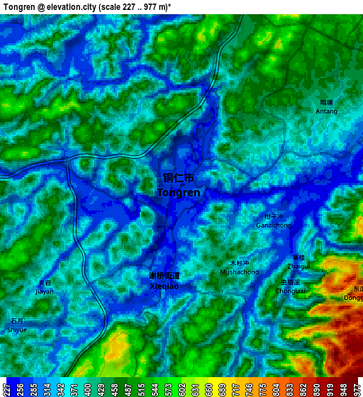
These maps also provides idea of topography and contour of this city, they are displayed at different zoom levels. More info about maps, scale and edge coordinates you can find below images.
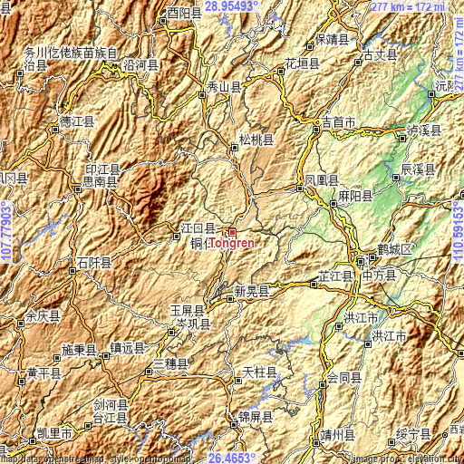
| \ | Map #1 | Map #2 | Topo.Map |
| Scale [m] | 237..594 m | 227..977 m | × |
| Scale [ft] | 778..1949 ft | 745..3205 ft | × |
| Average | 347.2 m = 1139 ft | 407.4 m = 1337 ft | × |
| Width | 8.65 km = 5.4 mi | 17.3 km = 10.7 mi | 276.8 km = 172 mi |
| Height | 8.65 km = 5.4 mi | 17.3 km = 10.7 mi | 276.8 km = 172 mi |
| ↑Max Latitude | 27.756116° | 27.794998° | 28.95493° |
| Latitude at center | 27.71722° | 27.71722° | 27.71722° |
| ↓Min Latitude | 27.67831° | 27.639387° | 26.4653° |
| ← Min Longitude | 109.141335° | 109.097389° | 107.77903° |
| Longitude center | 109.18528° | 109.18528° | 109.18528° |
| →Max Longitude | 109.229225° | 109.273171° | 110.59153° |
Nearby cities:
Cities around Tongren sort by population:
• Jinhe elevation 202 m
41.3 km,  90°
90°
• Yaoshi 256 m
35.1 km,  104°
104°
• Bozhou 313 m
38.7 km,  166°
166°
• Yangtou 302 m
22.7 km, 97°
• Youyupu 714 m
19.1 km,  195°
195°
• Chatian 549 m
20.8 km,  62°
62°
• Chadian 698 m
15.9 km, 198°
• Shuidatian 256 m
43.9 km,  70°
70°
• Bahuang 308 m
16.4 km,  270°
270°
• Tuojiang 378 m
46 km,  54°
54°
• Xinhuang 417 m
38.5 km,  187°
187°
• Wanshan 865 m
21.7 km, 174°
Multilingual:
 En español:
Tongren elevación 263 m.
 En France:
Tongren élévation 263 m.


Sources and notes:
- [note 1] Map square and city borders are not equal. Map elevation data is calculated only from area inside that square.
- [src 1] Elevation data from geonames database provided with same terms of usage.
- [src 2] The elevation map of Tongren is generated using elevation data from NASA's 3 arcsec (90m) resolution SRTM data.
- [src 3] Base (background) map © OpenStreetMap contributors tiles are generated by Geofabrik and OpenTopoMap.
Copyright & License:
This Tongren Elevation Map is licensed under CC BY-SA. You may reuse any part from this page, if you give a proper credit by linking to this URL:
 More info on terms of use page.