Tianfu elevation
Tianfu (Shandong), China elevation is 45 meters and Tianfu elevation in feet is 148 ft above sea level [src 1]. Tianfu is a seat of a third-order administrative division (feature code) with elevation that is 513 meters (1683 ft) smaller than average city elevation in China.
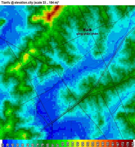
Below is the Elevation map of Tianfu, which displays elevation range with different colors. Scale of the first map is from 33 to 184 m (108 to 604 ft) with average elevation of 68 meters (=223 ft) [note 1]
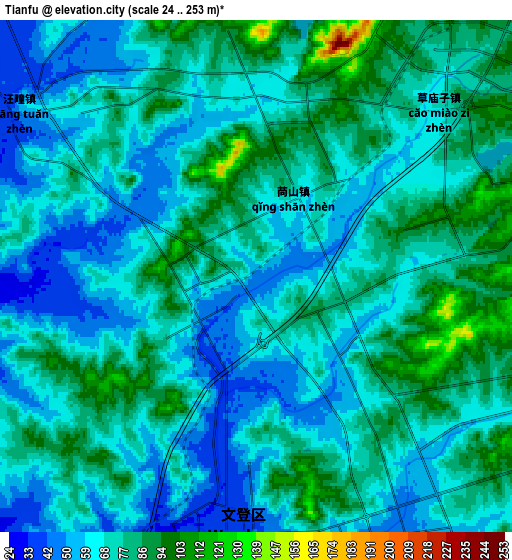
These maps also provides idea of topography and contour of this city, they are displayed at different zoom levels. More info about maps, scale and edge coordinates you can find below images.
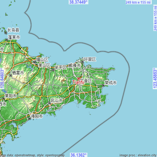
| \ | Map #1 | Map #2 | Topo.Map |
| Scale [m] | 33..184 m | 24..253 m | × |
| Scale [ft] | 108..604 ft | 79..830 ft | × |
| Average | 68 m = 223 ft | 71.5 m = 235 ft | × |
| Width | 7.78 km = 4.8 mi | 15.56 km = 9.7 mi | 248.9 km = 154.7 mi |
| Height | 7.78 km = 4.8 mi | 15.56 km = 9.7 mi | 248.9 km = 154.7 mi |
| ↑Max Latitude | 37.298626° | 37.333576° | 38.37449° |
| Latitude at center | 37.26366° | 37.26366° | 37.26366° |
| ↓Min Latitude | 37.228678° | 37.193679° | 36.1362° |
| ← Min Longitude | 122.008335° | 121.964389° | 120.64603° |
| Longitude center | 122.05228° | 122.05228° | 122.05228° |
| →Max Longitude | 122.096225° | 122.140171° | 123.45853° |
Nearby cities:
Cities around Tianfu sort by population:
• Yantai elevation 22 m
59 km,  293°
293°
• Weihai 14 m
27.8 km,  11°
11°
• Dongcun 38 m
96 km,  235°
235°
• Yatou 12 m
36.1 km,  109°
109°
• Qingyang 12 m
74.8 km, 290°
• Ninghai 12 m
41.5 km, 288°
• Xiangyang 24 m
65.3 km,  297°
297°
• Chengqu 25 m
61.1 km,  229°
229°
• Huanghai 20 m
59.6 km, 294°
• Ningjin 41 m
50.4 km,  127°
127°
• Wenhua 12 m
43.3 km, 289°
• Huancuilou 12 m
26.9 km, 11°
Multilingual:
 En español:
Tianfu elevación 45 m.
 En France:
Tianfu élévation 45 m.


Sources and notes:
- [note 1] Map square and city borders are not equal. Map elevation data is calculated only from area inside that square.
- [src 1] Elevation data from geonames database provided with same terms of usage.
- [src 2] The elevation map of Tianfu is generated using elevation data from NASA's 3 arcsec (90m) resolution SRTM data.
- [src 3] Base (background) map © OpenStreetMap contributors tiles are generated by Geofabrik and OpenTopoMap.
Copyright & License:
This Tianfu Elevation Map is licensed under CC BY-SA. You may reuse any part from this page, if you give a proper credit by linking to this URL:
 More info on terms of use page.