Dongcun elevation
Dongcun (Shandong), China elevation is 38 meters and Dongcun elevation in feet is 125 ft above sea level [src 1]. Dongcun is a populated place (feature code) with elevation that is 520 meters (1706 ft) smaller than average city elevation in China.
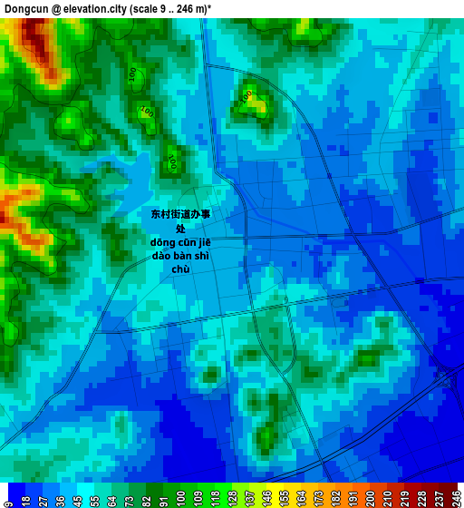
Below is the Elevation map of Dongcun, which displays elevation range with different colors. Scale of the first map is from 9 to 246 m (30 to 807 ft) with average elevation of 53 meters (=174 ft) [note 1]
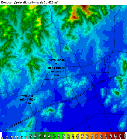
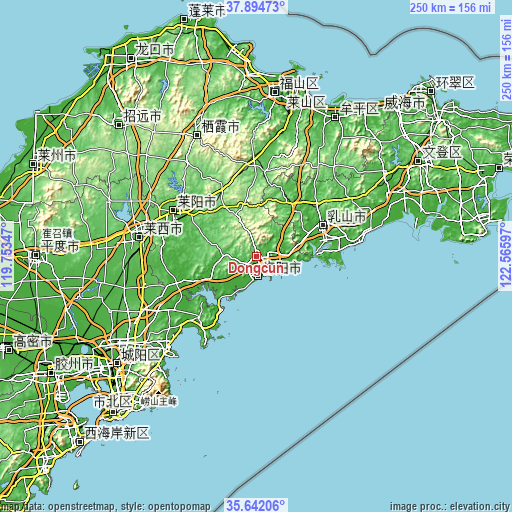
These maps also provides idea of topography and contour of this city, they are displayed at different zoom levels. More info about maps, scale and edge coordinates you can find below images.
| \ | Map #1 | Map #2 | Topo.Map |
| Scale [m] | 9..246 m | 0..452 m | × |
| Scale [ft] | 30..807 ft | 0..1483 ft | × |
| Average | 53 m = 174 ft | 66.9 m = 219 ft | × |
| Width | 7.83 km = 4.9 mi | 15.66 km = 9.7 mi | 250.5 km = 155.7 mi |
| Height | 7.83 km = 4.9 mi | 15.66 km = 9.7 mi | 250.5 km = 155.7 mi |
| ↑Max Latitude | 36.811861° | 36.847036° | 37.89473° |
| Latitude at center | 36.77667° | 36.77667° | 36.77667° |
| ↓Min Latitude | 36.741463° | 36.706239° | 35.64206° |
| ← Min Longitude | 121.115775° | 121.071829° | 119.75347° |
| Longitude center | 121.15972° | 121.15972° | 121.15972° |
| →Max Longitude | 121.203665° | 121.247611° | 122.56597° |
Nearby cities:
Cities around Dongcun sort by population:
• Yantai elevation 22 m
81.7 km,  17°
17°
• Laiyang 40 m
45.4 km,  299°
299°
• Zhuangyuan 135 m
65.8 km,  333°
333°
• Laixi 54 m
57.1 km,  279°
279°
• Jimo 25 m
75.7 km,  235°
235°
• Qingyang 12 m
80.4 km,  6°
6°
• Ninghai 12 m
78.4 km,  30°
30°
• Qingshancun 57 m
81.3 km,  211°
211°
• Beizhai 89 m
83.8 km,  222°
222°
• Huanghai 20 m
83 km, 17°
• Wenhua 12 m
78.2 km, 29°
• Chengqu 25 m
35.8 km,  65°
65°
Multilingual:
 En español:
Dongcun elevación 38 m.
 En France:
Dongcun élévation 38 m.


Sources and notes:
- [note 1] Map square and city borders are not equal. Map elevation data is calculated only from area inside that square.
- [src 1] Elevation data from geonames database provided with same terms of usage.
- [src 2] The elevation map of Dongcun is generated using elevation data from NASA's 3 arcsec (90m) resolution SRTM data.
- [src 3] Base (background) map © OpenStreetMap contributors tiles are generated by Geofabrik and OpenTopoMap.
Copyright & License:
This Dongcun Elevation Map is licensed under CC BY-SA. You may reuse any part from this page, if you give a proper credit by linking to this URL:
 More info on terms of use page.