Xiangzhou elevation
Xiangzhou (Guangxi), China elevation is 77 meters and Xiangzhou elevation in feet is 253 ft above sea level [src 1]. Xiangzhou is a seat of a third-order administrative division (feature code) with elevation that is 481 meters (1578 ft) smaller than average city elevation in China.
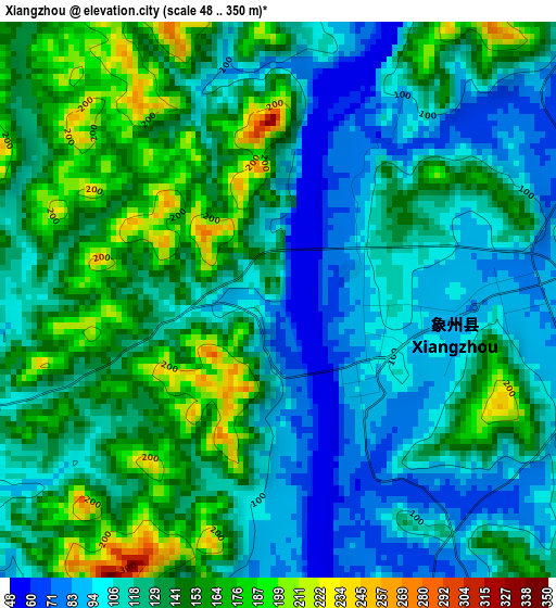
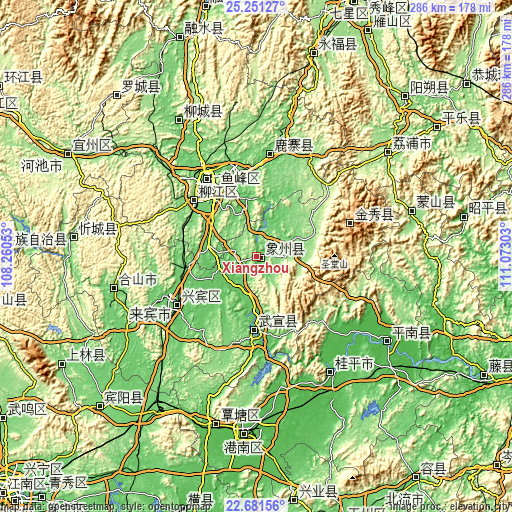
Below is the Elevation map of Xiangzhou, which displays elevation range with different colors. Scale of the first map is from 48 to 350 m (157 to 1148 ft) with average elevation of 128.2 meters (=421 ft) [note 1]
These maps also provides idea of topography and contour of this city, they are displayed at different zoom levels. More info about maps, scale and edge coordinates you can find below images.
| \ | Map #1 | Topo.Map |
| Scale [m] | 48..350 m | × |
| Scale [ft] | 157..1148 ft | × |
| Average | 128.2 m = 421 ft | × |
| Width | 8.93 km = 5.5 mi | 285.7 km = 177.5 mi |
| Height | 8.93 km = 5.5 mi | 285.7 km = 177.5 mi |
| ↑Max Latitude | 24.012968° | 25.25127° |
| Latitude at center | 23.97282° | 23.97282° |
| ↓Min Latitude | 23.932659° | 22.68156° |
| ← Min Longitude | 109.622835° | 108.26053° |
| Longitude center | 109.66678° | 109.66678° |
| →Max Longitude | 109.710725° | 111.07303° |
Nearby cities:
Cities around Xiangzhou sort by population:
• Guiping elevation 44 m
76.6 km,  147°
147°
• Luorong 76 m
48.5 km,  353°
353°
• Pingnan 39 m
87.8 km,  123°
123°
• Laibin 83 m
50.8 km,  233°
233°
• Licheng 170 m
94.3 km,  50°
50°
• Mengshan 157 m
90.4 km,  72°
72°
• Dabu 100 m
88.7 km,  330°
330°
• Luzhai 94 m
58.7 km,  6°
6°
• Jinxiu 908 m
55.2 km, 70°
• Liuzhou 94 m
47.1 km,  323°
323°
• Labu 109 m
46.5 km,  313°
313°
• Wuxuan 68 m
38.7 km,  182°
182°
Multilingual:
 En español:
Xiangzhou elevación 77 m.
 En France:
Xiangzhou élévation 77 m.
 Auf Deutsch:
Xiangzhou höhe über dem Meeresspiegel ist 77 m.

Sources and notes:
- [note 1] Map square and city borders are not equal. Map elevation data is calculated only from area inside that square.
- [src 1] Elevation data from geonames database provided with same terms of usage.
- [src 2] The elevation map of Xiangzhou is generated using elevation data from NASA's 3 arcsec (90m) resolution SRTM data.
- [src 3] Base (background) map © OpenStreetMap contributors tiles are generated by Geofabrik and OpenTopoMap.
Copyright & License:
This Xiangzhou Elevation Map is licensed under CC BY-SA. You may reuse any part from this page, if you give a proper credit by linking to this URL:
 More info on terms of use page.