Xining elevation
Xining (Qinghai), China elevation is 2275 meters and Xining elevation in feet is 7464 ft above sea level [src 1]. Xining is a seat of a first-order administrative division (feature code) with elevation that is 1717 meters (5633 ft) bigger than average city elevation in China.
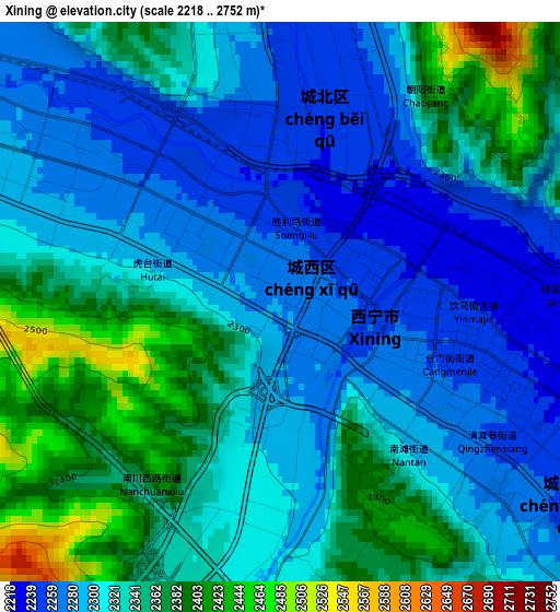
Below is the Elevation map of Xining, which displays elevation range with different colors. Scale of the first map is from 2218 to 2752 m (7277 to 9029 ft) with average elevation of 2322.2 meters (=7619 ft) [note 1]
These maps also provides idea of topography and contour of this city, they are displayed at different zoom levels. More info about maps, scale and edge coordinates you can find below images.
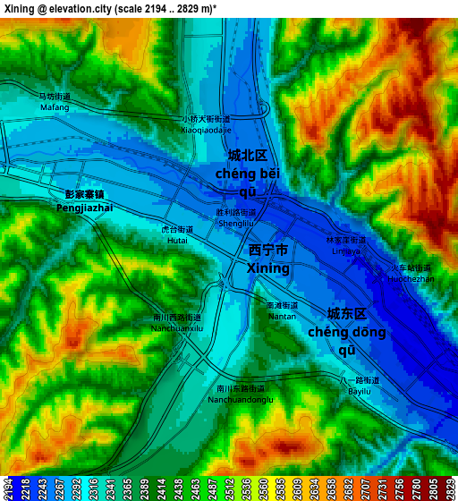
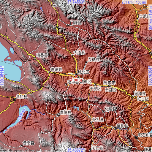
| \ | Map #1 | Map #2 | Topo.Map |
| Scale [m] | 2218..2752 m | 2194..2829 m | × |
| Scale [ft] | 7277..9029 ft | 7198..9281 ft | × |
| Average | 2322.2 m = 7619 ft | 2412.5 m = 7915 ft | × |
| Width | 7.84 km = 4.9 mi | 15.69 km = 9.7 mi | 251 km = 156 mi |
| Height | 7.84 km = 4.9 mi | 15.69 km = 9.7 mi | 251 km = 156 mi |
| ↑Max Latitude | 36.6608° | 36.696044° | 37.74583° |
| Latitude at center | 36.62554° | 36.62554° | 36.62554° |
| ↓Min Latitude | 36.590264° | 36.554971° | 35.48872° |
| ← Min Longitude | 101.713445° | 101.669499° | 100.35114° |
| Longitude center | 101.75739° | 101.75739° | 101.75739° |
| →Max Longitude | 101.801335° | 101.845281° | 103.16364° |
Nearby cities:
Cities around Xining sort by population:
• Huazangsi elevation 2407 m
128.7 km,  72°
72°
• Rongwo 2506 m
125.7 km,  169°
169°
• Qabqa 2839 m
109.3 km,  249°
249°
• Jishi 1883 m
108.3 km,  143°
143°
• Haishiwan 1775 m
103.2 km,  107°
107°
• Magitang 2068 m
80.2 km,  162°
162°
• Sanjiaocheng 3002 m
73.7 km,  293°
293°
• Heyin 2221 m
71 km,  204°
204°
• Huangyuan Chengguanzhen 2656 m
43.9 km,  279°
279°
• Qiaotou 2487 m
35.2 km,  347°
347°
• Weiyuan 2592 m
32.8 km,  39°
39°
• Lushar 2738 m
23.4 km,  227°
227°
Multilingual:
 En español:
Xining elevación 2275 m.
 En France:
Xining élévation 2275 m.


Sources and notes:
- [note 1] Map square and city borders are not equal. Map elevation data is calculated only from area inside that square.
- [src 1] Elevation data from geonames database provided with same terms of usage.
- [src 2] The elevation map of Xining is generated using elevation data from NASA's 3 arcsec (90m) resolution SRTM data.
- [src 3] Base (background) map © OpenStreetMap contributors tiles are generated by Geofabrik and OpenTopoMap.
Copyright & License:
This Xining Elevation Map is licensed under CC BY-SA. You may reuse any part from this page, if you give a proper credit by linking to this URL:
 More info on terms of use page.