Xuyong elevation
Xuyong (Sichuan), China elevation is 367 meters and Xuyong elevation in feet is 1204 ft above sea level [src 1]. Xuyong is a seat of a third-order administrative division (feature code) with elevation that is 191 meters (627 ft) smaller than average city elevation in China.
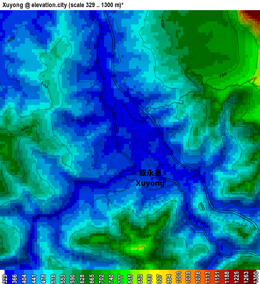
Below is the Elevation map of Xuyong, which displays elevation range with different colors. Scale of the first map is from 329 to 1300 m (1079 to 4265 ft) with average elevation of 496 meters (=1627 ft) [note 1]
These maps also provides idea of topography and contour of this city, they are displayed at different zoom levels. More info about maps, scale and edge coordinates you can find below images.
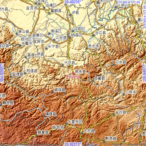
| \ | Map #1 | Topo.Map |
| Scale [m] | 329..1300 m | × |
| Scale [ft] | 1079..4265 ft | × |
| Average | 496 m = 1627 ft | × |
| Width | 8.61 km = 5.3 mi | 275.7 km = 171.3 mi |
| Height | 8.61 km = 5.3 mi | 275.7 km = 171.3 mi |
| ↑Max Latitude | 28.208653° | 29.40235° |
| Latitude at center | 28.16992° | 28.16992° |
| ↓Min Latitude | 28.131173° | 26.92313° |
| ← Min Longitude | 105.390575° | 104.02827° |
| Longitude center | 105.43452° | 105.43452° |
| →Max Longitude | 105.478465° | 106.84077° |
Nearby cities:
Cities around Xuyong sort by population:
• Xunchang elevation 515 m
77.2 km,  294°
294°
• Taiping 327 m
59.2 km,  93°
93°
• Guandu 660 m
79 km,  55°
55°
• Changsha 241 m
79.1 km,  43°
43°
• Luzhou 256 m
80.1 km,  359°
359°
• Donghuang 1208 m
78.6 km,  76°
76°
• Jiang’an 282 m
72.2 km,  330°
330°
• Changning 264 m
67.7 km,  312°
312°
• Naxi 253 m
67.5 km,  354°
354°
• Zhaxi 1633 m
57.9 km,  232°
232°
• Gulin 506 m
39.5 km,  111°
111°
• Zhongcheng 354 m
25.3 km, 307°
Multilingual:
 En español:
Xuyong elevación 367 m.
 En France:
Xuyong élévation 367 m.


Sources and notes:
- [note 1] Map square and city borders are not equal. Map elevation data is calculated only from area inside that square.
- [src 1] Elevation data from geonames database provided with same terms of usage.
- [src 2] The elevation map of Xuyong is generated using elevation data from NASA's 3 arcsec (90m) resolution SRTM data.
- [src 3] Base (background) map © OpenStreetMap contributors tiles are generated by Geofabrik and OpenTopoMap.
Copyright & License:
This Xuyong Elevation Map is licensed under CC BY-SA. You may reuse any part from this page, if you give a proper credit by linking to this URL:
 More info on terms of use page.