Changsha elevation
Changsha (Guizhou), China elevation is 241 meters and Changsha elevation in feet is 791 ft above sea level [src 1]. Changsha is a seat of a fourth-order administrative division (feature code) with elevation that is 317 meters (1040 ft) smaller than average city elevation in China.
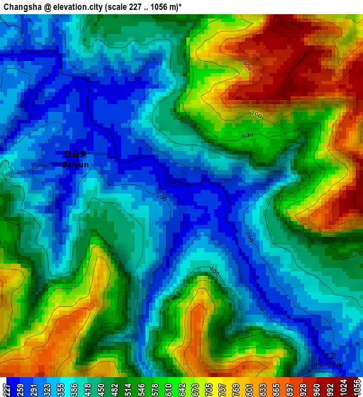
Below is the Elevation map of Changsha, which displays elevation range with different colors. Scale of the first map is from 227 to 1056 m (745 to 3465 ft) with average elevation of 503 meters (=1650 ft) [note 1]
These maps also provides idea of topography and contour of this city, they are displayed at different zoom levels. More info about maps, scale and edge coordinates you can find below images.
| \ | Map #1 | Topo.Map |
| Scale [m] | 227..1056 m | × |
| Scale [ft] | 745..3465 ft | × |
| Average | 503 m = 1650 ft | × |
| Width | 8.57 km = 5.3 mi | 274.3 km = 170.4 mi |
| Height | 8.57 km = 5.3 mi | 274.3 km = 170.4 mi |
| ↑Max Latitude | 28.726324° | 29.91408° |
| Latitude at center | 28.68778° | 28.68778° |
| ↓Min Latitude | 28.649222° | 27.44695° |
| ← Min Longitude | 105.945775° | 104.58347° |
| Longitude center | 105.98972° | 105.98972° |
| →Max Longitude | 106.033665° | 107.39597° |
Nearby cities:
Cities around Changsha sort by population:
• Wenshui elevation 1039 m
58.7 km,  116°
116°
• Fubao 246 m
12.4 km,  43°
43°
• Taiping 327 m
61 km,  175°
175°
• Guandu 660 m
17.3 km,  140°
140°
• Caijia 330 m
42.1 km,  54°
54°
• Sanchahe 1157 m
47.9 km, 116°
• Liangcunchang 1070 m
52.7 km,  126°
126°
• Sangmu 1179 m
59.2 km,  152°
152°
• Xiantan 317 m
24.6 km, 53°
• Luzhou 256 m
59.4 km,  292°
292°
• Donghuang 1208 m
45.2 km, 150°
• Hejiang 236 m
20.5 km,  312°
312°
Multilingual:
 En español:
Changsha elevación 241 m.
 En France:
Changsha élévation 241 m.
 Auf Deutsch:
Changsha höhe über dem Meeresspiegel ist 241 m.

Sources and notes:
- [note 1] Map square and city borders are not equal. Map elevation data is calculated only from area inside that square.
- [src 1] Elevation data from geonames database provided with same terms of usage.
- [src 2] The elevation map of Changsha is generated using elevation data from NASA's 3 arcsec (90m) resolution SRTM data.
- [src 3] Base (background) map © OpenStreetMap contributors tiles are generated by Geofabrik and OpenTopoMap.
Copyright & License:
This Changsha Elevation Map is licensed under CC BY-SA. You may reuse any part from this page, if you give a proper credit by linking to this URL:
 More info on terms of use page.