Yunfu elevation
Yunfu (Guangdong), China elevation is 76 meters and Yunfu elevation in feet is 249 ft above sea level [src 1]. Yunfu is a seat of a second-order administrative division (feature code) with elevation that is 482 meters (1581 ft) smaller than average city elevation in China.
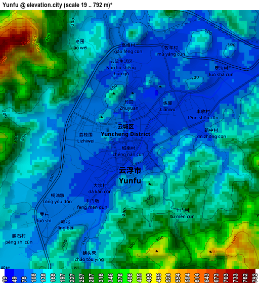
Below is the Elevation map of Yunfu, which displays elevation range with different colors. Scale of the first map is from 19 to 792 m (62 to 2598 ft) with average elevation of 174.8 meters (=573 ft) [note 1]
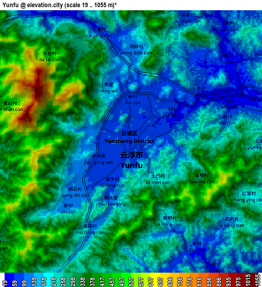
These maps also provides idea of topography and contour of this city, they are displayed at different zoom levels. More info about maps, scale and edge coordinates you can find below images.
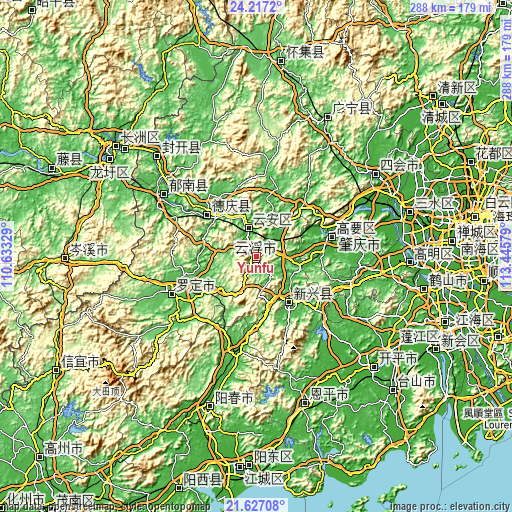
| \ | Map #1 | Map #2 | Topo.Map |
| Scale [m] | 19..792 m | 19..1055 m | × |
| Scale [ft] | 62..2598 ft | 62..3461 ft | × |
| Average | 174.8 m = 573 ft | 260.7 m = 855 ft | × |
| Width | 9 km = 5.6 mi | 18 km = 11.2 mi | 288 km = 179 mi |
| Height | 9 km = 5.6 mi | 18 km = 11.2 mi | 288 km = 179 mi |
| ↑Max Latitude | 22.968797° | 23.009252° | 24.2172° |
| Latitude at center | 22.92833° | 22.92833° | 22.92833° |
| ↓Min Latitude | 22.887851° | 22.847359° | 21.62708° |
| ← Min Longitude | 111.995595° | 111.951649° | 110.63329° |
| Longitude center | 112.03954° | 112.03954° | 112.03954° |
| →Max Longitude | 112.083485° | 112.127431° | 113.44579° |
Nearby cities:
Cities around Yunfu sort by population:
• Zhaoqing elevation 8 m
45.2 km,  72°
72°
• Yangchun 22 m
88.7 km,  197°
197°
• Encheng 25 m
86.8 km,  161°
161°
• Lubu 18 m
36.8 km,  42°
42°
• Ducheng 23 m
62.9 km,  303°
303°
• Nanjie 43 m
88.3 km,  27°
27°
• Jiangkou 35 m
79.4 km,  315°
315°
• Luocheng 50 m
51.4 km,  249°
249°
• Nan’an 13 m
43.7 km, 74°
• Gaoyao 22 m
42.9 km,  75°
75°
• Decheng 13 m
35.7 km,  311°
311°
• Xincheng 33 m
31.6 km,  143°
143°
Multilingual:
 En español:
Yunfu elevación 76 m.
 En France:
Yunfu élévation 76 m.


Sources and notes:
- [note 1] Map square and city borders are not equal. Map elevation data is calculated only from area inside that square.
- [src 1] Elevation data from geonames database provided with same terms of usage.
- [src 2] The elevation map of Yunfu is generated using elevation data from NASA's 3 arcsec (90m) resolution SRTM data.
- [src 3] Base (background) map © OpenStreetMap contributors tiles are generated by Geofabrik and OpenTopoMap.
Copyright & License:
This Yunfu Elevation Map is licensed under CC BY-SA. You may reuse any part from this page, if you give a proper credit by linking to this URL:
 More info on terms of use page.