Ziketan elevation
Ziketan (Qinghai), China elevation is 3299 meters and Ziketan elevation in feet is 10823 ft above sea level [src 1]. Ziketan is a seat of a third-order administrative division (feature code) with elevation that is 2741 meters (8993 ft) bigger than average city elevation in China.
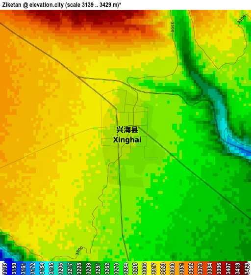
Below is the Elevation map of Ziketan, which displays elevation range with different colors. Scale of the first map is from 3139 to 3429 m (10299 to 11250 ft) with average elevation of 3301.1 meters (=10830 ft) [note 1]
These maps also provides idea of topography and contour of this city, they are displayed at different zoom levels. More info about maps, scale and edge coordinates you can find below images.
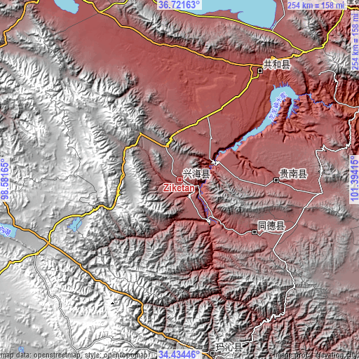
| \ | Map #1 | Topo.Map |
| Scale [m] | 3139..3429 m | × |
| Scale [ft] | 10299..11250 ft | × |
| Average | 3301.1 m = 10830 ft | × |
| Width | 7.95 km = 4.9 mi | 254.3 km = 158 mi |
| Height | 7.95 km = 4.9 mi | 254.3 km = 158 mi |
| ↑Max Latitude | 35.62194° | 36.72163° |
| Latitude at center | 35.58621° | 35.58621° |
| ↓Min Latitude | 35.550464° | 34.43446° |
| ← Min Longitude | 99.943955° | 98.58165° |
| Longitude center | 99.9879° | 99.9879° |
| →Max Longitude | 100.031845° | 101.39415° |
Nearby cities:
Cities around Ziketan sort by population:
• Rongwo elevation 2506 m
183.6 km,  92°
92°
• Kequ 4020 m
180 km,  182°
182°
• Youganning 3527 m
175.3 km,  122°
122°
• Machali 4350 m
175.1 km,  245°
245°
• Lushar 2738 m
173.3 km,  54°
54°
• Sanjiaocheng 3002 m
171.1 km,  32°
32°
• Huangyuan Chengguanzhen 2656 m
168.1 km,  43°
43°
• Heyin 2221 m
139.5 km,  68°
68°
• Dawu 3721 m
126.5 km,  169°
169°
• Qabqa 2839 m
95.6 km, 36°
• Mangqu 3082 m
69.1 km, 90°
• Gabasumdo 3113 m
62.6 km,  125°
125°
Multilingual:
 En español:
Ziketan elevación 3299 m.
 En France:
Ziketan élévation 3299 m.
 Auf Deutsch:
Ziketan höhe über dem Meeresspiegel ist 3299 m.

Sources and notes:
- [note 1] Map square and city borders are not equal. Map elevation data is calculated only from area inside that square.
- [src 1] Elevation data from geonames database provided with same terms of usage.
- [src 2] The elevation map of Ziketan is generated using elevation data from NASA's 3 arcsec (90m) resolution SRTM data.
- [src 3] Base (background) map © OpenStreetMap contributors tiles are generated by Geofabrik and OpenTopoMap.
Copyright & License:
This Ziketan Elevation Map is licensed under CC BY-SA. You may reuse any part from this page, if you give a proper credit by linking to this URL:
 More info on terms of use page.