Tcholliré elevation
Tcholliré (North), Cameroon elevation is 382 meters and Tcholliré elevation in feet is 1253 ft above sea level [src 1]. Tcholliré is a populated place (feature code) with elevation that is 293 meters (961 ft) smaller than average city elevation in Cameroon.
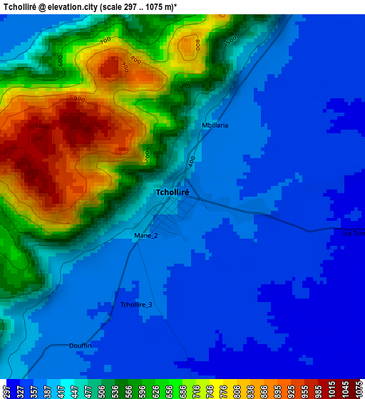
Below is the Elevation map of Tcholliré, which displays elevation range with different colors. Scale of the first map is from 297 to 1075 m (974 to 3527 ft) with average elevation of 476.8 meters (=1564 ft) [note 1]
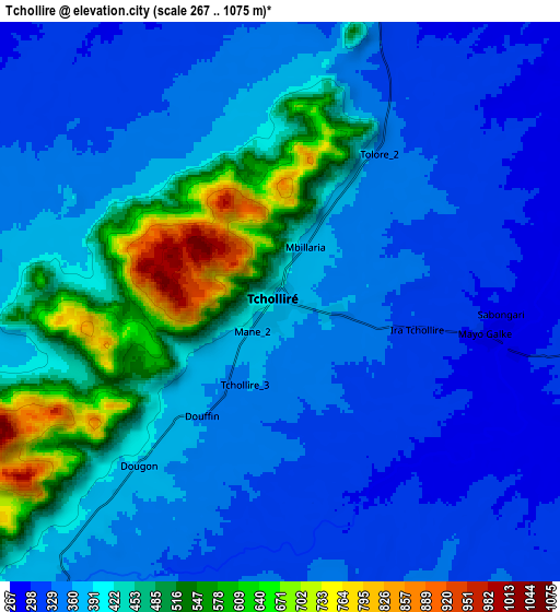
These maps also provides idea of topography and contour of this city, they are displayed at different zoom levels. More info about maps, scale and edge coordinates you can find below images.
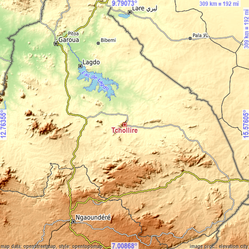
| \ | Map #1 | Map #2 | Topo.Map |
| Scale [m] | 297..1075 m | 267..1075 m | × |
| Scale [ft] | 974..3527 ft | 876..3527 ft | × |
| Average | 476.8 m = 1564 ft | 397.3 m = 1303 ft | × |
| Width | 9.67 km = 6 mi | 19.34 km = 12 mi | 309.3 km = 192.2 mi |
| Height | 9.67 km = 6 mi | 19.34 km = 12 mi | 309.4 km = 192.3 mi |
| ↑Max Latitude | 8.445671° | 8.489137° | 9.79073° |
| Latitude at center | 8.4022° | 8.4022° | 8.4022° |
| ↓Min Latitude | 8.358724° | 8.315243° | 7.00868° |
| ← Min Longitude | 14.125855° | 14.081909° | 12.76355° |
| Longitude center | 14.1698° | 14.1698° | 14.1698° |
| →Max Longitude | 14.213745° | 14.257691° | 15.57605° |
Nearby cities:
Cities around Tcholliré sort by population:
• Garoua elevation 199 m
131.1 km,  319°
319°
• Ngaoundéré 1128 m
135.7 km,  208°
208°
• Guider 346 m
172 km,  351°
351°
• Meïganga 970 m
210.1 km,  176°
176°
• Kaélé 373 m
192.3 km,  9°
9°
• Lagdo 234 m
91.6 km, 322°
• Pitoa 187 m
131.5 km,  326°
326°
• Rey Bouba 235 m
30.1 km,  1°
1°
• Bélel 1448 m
153.1 km,  169°
169°
• Poli 477 m
102.5 km,  274°
274°
• Djohong 1271 m
184 km,  161°
161°
• Tignère 1104 m
203.2 km,  235°
235°
Multilingual:
 En español:
Tcholliré elevación 382 m.
 En France:
Tcholliré élévation 382 m.
 Auf Deutsch:
Tcholliré höhe über dem Meeresspiegel ist 382 m.

Sources and notes:
- [note 1] Map square and city borders are not equal. Map elevation data is calculated only from area inside that square.
- [src 1] Elevation data from geonames database provided with same terms of usage.
- [src 2] The elevation map of Tcholliré is generated using elevation data from NASA's 3 arcsec (90m) resolution SRTM data.
- [src 3] Base (background) map © OpenStreetMap contributors tiles are generated by Geofabrik and OpenTopoMap.
Copyright & License:
This Tcholliré Elevation Map is licensed under CC BY-SA. You may reuse any part from this page, if you give a proper credit by linking to this URL:
 More info on terms of use page.