Tignère elevation
Tignère (Adamaoua), Cameroon elevation is 1104 meters and Tignère elevation in feet is 3622 ft above sea level [src 1]. Tignère is a populated place (feature code) with elevation that is 429 meters (1407 ft) bigger than average city elevation in Cameroon.
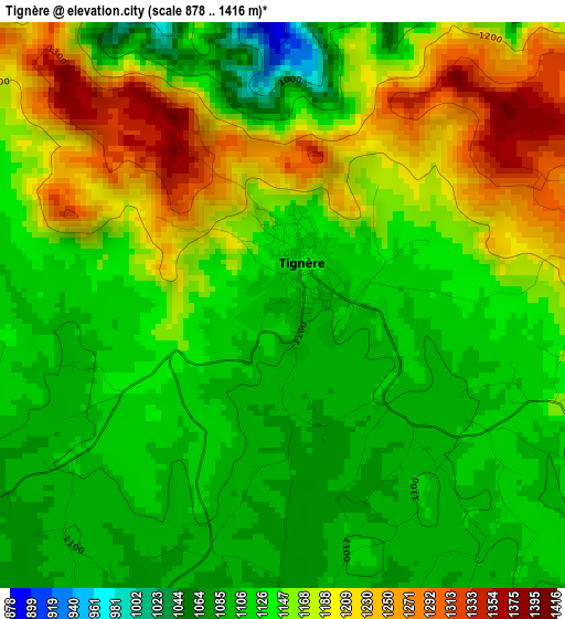
Below is the Elevation map of Tignère, which displays elevation range with different colors. Scale of the first map is from 878 to 1416 m (2881 to 4646 ft) with average elevation of 1148.8 meters (=3769 ft) [note 1]
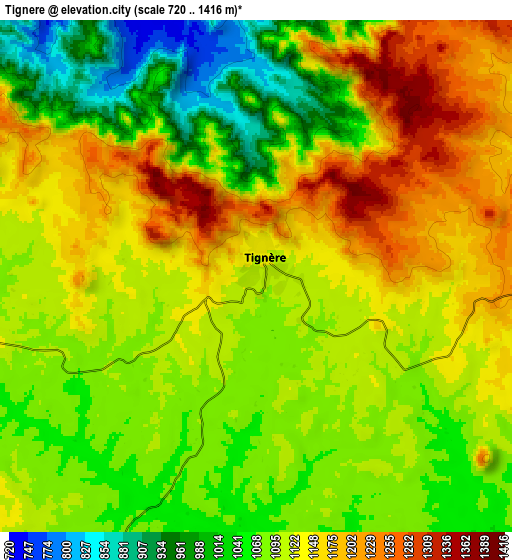
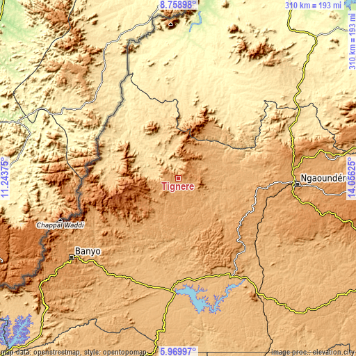
These maps also provides idea of topography and contour of this city, they are displayed at different zoom levels. More info about maps, scale and edge coordinates you can find below images.
| \ | Map #1 | Map #2 | Topo.Map |
| Scale [m] | 878..1416 m | 720..1416 m | × |
| Scale [ft] | 2881..4646 ft | 2362..4646 ft | × |
| Average | 1148.8 m = 3769 ft | 1105.3 m = 3626 ft | × |
| Width | 9.69 km = 6 mi | 19.38 km = 12 mi | 310.1 km = 192.7 mi |
| Height | 9.69 km = 6 mi | 19.38 km = 12 mi | 310.1 km = 192.7 mi |
| ↑Max Latitude | 7.41025° | 7.453827° | 8.75898° |
| Latitude at center | 7.36667° | 7.36667° | 7.36667° |
| ↓Min Latitude | 7.323085° | 7.279496° | 5.96997° |
| ← Min Longitude | 12.606055° | 12.562109° | 11.24375° |
| Longitude center | 12.65° | 12.65° | 12.65° |
| →Max Longitude | 12.693945° | 12.737891° | 14.05625° |
Nearby cities:
Cities around Tignère sort by population:
• Ngaoundéré elevation 1128 m
103.2 km,  92°
92°
• Meïganga 970 m
205.2 km,  117°
117°
• Banyo 1077 m
114.7 km,  233°
233°
• Tibati 871 m
100.3 km,  181°
181°
• Lagdo 234 m
218.8 km,  30°
30°
• Tcholliré 382 m
203.2 km,  55°
55°
• Kontcha 425 m
81 km,  325°
325°
• Bélel 1448 m
199.8 km,  100°
100°
• Bankim 731 m
191.7 km,  221°
221°
• Poli 477 m
139.4 km, 27°
• Yoko 992 m
207.1 km,  190°
190°
• Somié 771 m
168.1 km, 233°
Multilingual:
 En español:
Tignère elevación 1104 m.
 En France:
Tignère élévation 1104 m.
 Auf Deutsch:
Tignère höhe über dem Meeresspiegel ist 1104 m.

Sources and notes:
- [note 1] Map square and city borders are not equal. Map elevation data is calculated only from area inside that square.
- [src 1] Elevation data from geonames database provided with same terms of usage.
- [src 2] The elevation map of Tignère is generated using elevation data from NASA's 3 arcsec (90m) resolution SRTM data.
- [src 3] Base (background) map © OpenStreetMap contributors tiles are generated by Geofabrik and OpenTopoMap.
Copyright & License:
This Tignère Elevation Map is licensed under CC BY-SA. You may reuse any part from this page, if you give a proper credit by linking to this URL:
 More info on terms of use page.