Pitoa elevation
Pitoa (North), Cameroon elevation is 187 meters and Pitoa elevation in feet is 614 ft above sea level [src 1]. Pitoa is a populated place (feature code) with elevation that is 488 meters (1601 ft) smaller than average city elevation in Cameroon.
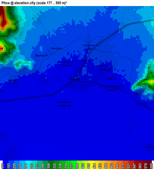
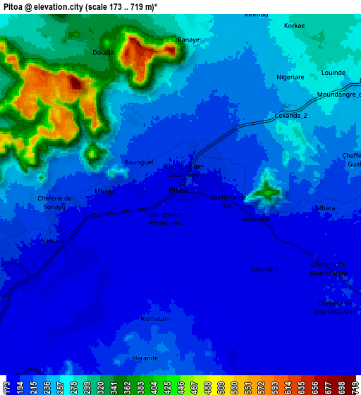
Below is the Elevation map of Pitoa, which displays elevation range with different colors. Scale of the first map is from 177 to 595 m (581 to 1952 ft) with average elevation of 203.1 meters (=666 ft) [note 1]
These maps also provides idea of topography and contour of this city, they are displayed at different zoom levels. More info about maps, scale and edge coordinates you can find below images.
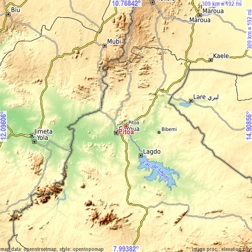
| \ | Map #1 | Map #2 | Topo.Map |
| Scale [m] | 177..595 m | 173..719 m | × |
| Scale [ft] | 581..1952 ft | 568..2359 ft | × |
| Average | 203.1 m = 666 ft | 239 m = 784 ft | × |
| Width | 9.64 km = 6 mi | 19.28 km = 12 mi | 308.5 km = 191.7 mi |
| Height | 9.64 km = 6 mi | 19.28 km = 12 mi | 308.5 km = 191.7 mi |
| ↑Max Latitude | 9.427255° | 9.470604° | 10.76842° |
| Latitude at center | 9.3839° | 9.3839° | 9.3839° |
| ↓Min Latitude | 9.34054° | 9.297175° | 7.99382° |
| ← Min Longitude | 13.458365° | 13.414419° | 12.09606° |
| Longitude center | 13.50231° | 13.50231° | 13.50231° |
| →Max Longitude | 13.546255° | 13.590201° | 14.90856° |
Nearby cities:
Cities around Pitoa sort by population:
• Garoua elevation 199 m
14.7 km,  231°
231°
• Maroua 406 m
161.1 km,  33°
33°
• Mokolo 813 m
154.6 km,  12°
12°
• Guider 346 m
78.1 km,  38°
38°
• Kaélé 373 m
131.6 km,  52°
52°
• Lagdo 234 m
40.4 km,  153°
153°
• Tcholliré 382 m
131.5 km, 146°
• Bogo 343 m
192.9 km, 38°
• Rey Bouba 235 m
108.5 km,  136°
136°
• Mindif 396 m
152.2 km, 42°
• Poli 477 m
105 km,  195°
195°
• Koza 501 m
170.2 km, 14°
Multilingual:
 En español:
Pitoa elevación 187 m.
 En France:
Pitoa élévation 187 m.


Sources and notes:
- [note 1] Map square and city borders are not equal. Map elevation data is calculated only from area inside that square.
- [src 1] Elevation data from geonames database provided with same terms of usage.
- [src 2] The elevation map of Pitoa is generated using elevation data from NASA's 3 arcsec (90m) resolution SRTM data.
- [src 3] Base (background) map © OpenStreetMap contributors tiles are generated by Geofabrik and OpenTopoMap.
Copyright & License:
This Pitoa Elevation Map is licensed under CC BY-SA. You may reuse any part from this page, if you give a proper credit by linking to this URL:
 More info on terms of use page.