Antofagasta elevation
Antofagasta, Chile elevation is 31 meters and Antofagasta elevation in feet is 102 ft above sea level [src 1]. Antofagasta is a seat of a first-order administrative division (feature code) with elevation that is 244 meters (801 ft) smaller than average city elevation in Chile.
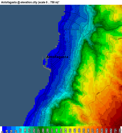
Below is the Elevation map of Antofagasta, which displays elevation range with different colors. Scale of the first map is from 0 to 750 m (0 to 2461 ft) with average elevation of 291.8 meters (=957 ft) [note 1]
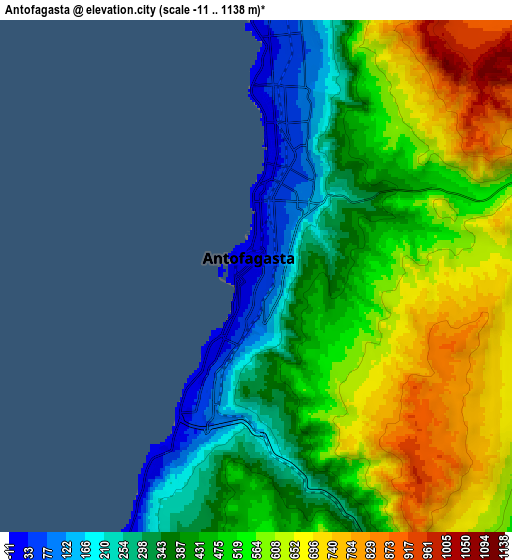
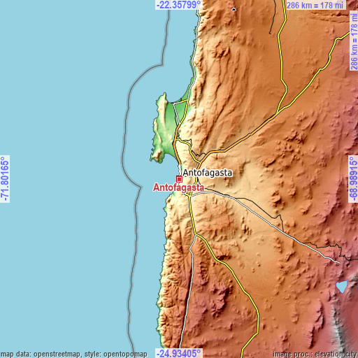
These maps also provides idea of topography and contour of this city, they are displayed at different zoom levels. More info about maps, scale and edge coordinates you can find below images.
| \ | Map #1 | Map #2 | Topo.Map |
| Scale [m] | 0..750 m | -11..1138 m | × |
| Scale [ft] | 0..2461 ft | -36..3734 ft | × |
| Average | 291.8 m = 957 ft | 489.7 m = 1607 ft | × |
| Width | 8.95 km = 5.6 mi | 17.9 km = 11.1 mi | 286.4 km = 178 mi |
| Height | 8.95 km = 5.6 mi | 17.9 km = 11.1 mi | 286.4 km = 178 mi |
| ↑Max Latitude | -23.6121° | -23.571828° | -22.35799° |
| Latitude at center | -23.65236° | -23.65236° | -23.65236° |
| ↓Min Latitude | -23.692608° | -23.732843° | -24.93405° |
| ← Min Longitude | -70.439345° | -70.483291° | -71.80165° |
| Longitude center | -70.3954° | -70.3954° | -70.3954° |
| →Max Longitude | -70.351455° | -70.307509° | -68.98915° |
Nearby cities:
Cities around Antofagasta sort by population:
• Iquique elevation 20 m
383.2 km,  3°
3°
• Calama 2275 m
200.9 km,  48°
48°
• Copiapó 397 m
413.1 km,  179°
179°
• Tocopilla 37 m
174.7 km,  6°
6°
• Diego de Almagro 1020 m
303.8 km,  173°
173°
• Taltal 1 m
195.3 km, 182°
• San Pedro de Atacama 2444 m
238.8 km,  69°
69°
• Pozo Almonte 1035 m
382.8 km, 9°
• Pica 1327 m
368.2 km,  17°
17°
• Chañaral 25 m
300 km, 184°
Multilingual:
 En español:
Antofagasta elevación 31 m.
 En France:
Antofagasta élévation 31 m.
 Auf Deutsch:
Antofagasta höhe über dem Meeresspiegel ist 31 m.

Sources and notes:
- [note 1] Map square and city borders are not equal. Map elevation data is calculated only from area inside that square.
- [src 1] Elevation data from geonames database provided with same terms of usage.
- [src 2] The elevation map of Antofagasta is generated using elevation data from NASA's 3 arcsec (90m) resolution SRTM data.
- [src 3] Base (background) map © OpenStreetMap contributors tiles are generated by Geofabrik and OpenTopoMap.
Copyright & License:
This Antofagasta Elevation Map is licensed under CC BY-SA. You may reuse any part from this page, if you give a proper credit by linking to this URL:
 More info on terms of use page.