San Pedro de Atacama elevation
San Pedro de Atacama (Antofagasta, Provincia de El Loa), Chile elevation is 2444 meters and San Pedro de Atacama elevation in feet is 8018 ft above sea level [src 1]. San Pedro de Atacama is a populated place (feature code) with elevation that is 2169 meters (7116 ft) bigger than average city elevation in Chile.
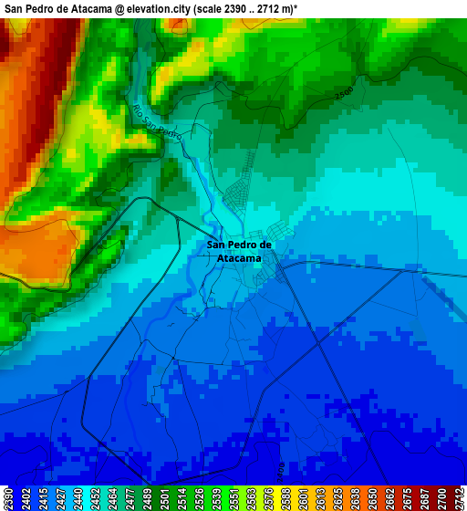
Below is the Elevation map of San Pedro de Atacama, which displays elevation range with different colors. Scale of the first map is from 2390 to 2712 m (7841 to 8898 ft) with average elevation of 2467 meters (=8094 ft) [note 1]
These maps also provides idea of topography and contour of this city, they are displayed at different zoom levels. More info about maps, scale and edge coordinates you can find below images.
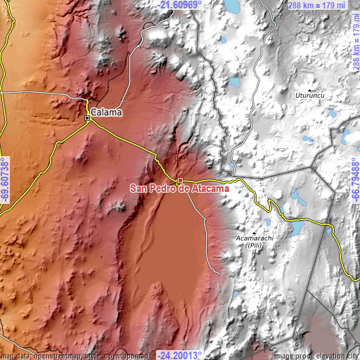
| \ | Map #1 | Topo.Map |
| Scale [m] | 2390..2712 m | × |
| Scale [ft] | 7841..8898 ft | × |
| Average | 2467 m = 8094 ft | × |
| Width | 9 km = 5.6 mi | 288 km = 179 mi |
| Height | 9 km = 5.6 mi | 288 km = 179 mi |
| ↑Max Latitude | -22.870615° | -21.60969° |
| Latitude at center | -22.9111° | -22.9111° |
| ↓Min Latitude | -22.951572° | -24.20013° |
| ← Min Longitude | -68.245075° | -69.60738° |
| Longitude center | -68.20113° | -68.20113° |
| →Max Longitude | -68.157185° | -66.79488° |
Nearby cities:
Cities around San Pedro de Atacama sort by population:
• Antofagasta elevation 31 m
238.8 km,  249°
249°
• Iquique 20 m
361.4 km,  326°
326°
• Calama 2275 m
89.7 km,  304°
304°
• Tocopilla 37 m
224.4 km,  293°
293°
• Diego de Almagro 1020 m
427.2 km,  205°
205°
• Taltal 1 m
361.6 km,  219°
219°
• Pozo Almonte 1035 m
337.7 km, 330°
• Pica 1327 m
293.3 km,  336°
336°
Multilingual:
 En español:
San Pedro de Atacama elevación 2444 m.
 En France:
San Pedro de Atacama élévation 2444 m.
 Auf Deutsch:
San Pedro de Atacama höhe über dem Meeresspiegel ist 2444 m.
 На русском:
Сан-Педро-де-Атакама высота над уровнем моря 2444 м
Sources and notes:
- [note 1] Map square and city borders are not equal. Map elevation data is calculated only from area inside that square.
- [src 1] Elevation data from geonames database provided with same terms of usage.
- [src 2] The elevation map of San Pedro de Atacama is generated using elevation data from NASA's 3 arcsec (90m) resolution SRTM data.
- [src 3] Base (background) map © OpenStreetMap contributors tiles are generated by Geofabrik and OpenTopoMap.
Copyright & License:
This San Pedro de Atacama Elevation Map is licensed under CC BY-SA. You may reuse any part from this page, if you give a proper credit by linking to this URL:
 More info on terms of use page.