Copiapó elevation
Copiapó (Atacama, Provincia de Copiapó), Chile elevation is 397 meters and Copiapó elevation in feet is 1302 ft above sea level [src 1]. Copiapó is a seat of a first-order administrative division (feature code) with elevation that is 122 meters (400 ft) bigger than average city elevation in Chile.
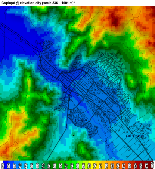
Below is the Elevation map of Copiapó, which displays elevation range with different colors. Scale of the first map is from 336 to 1001 m (1102 to 3284 ft) with average elevation of 524.8 meters (=1722 ft) [note 1]
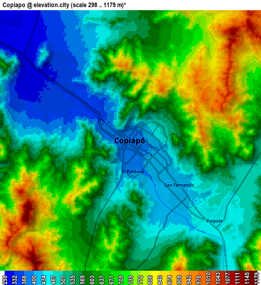
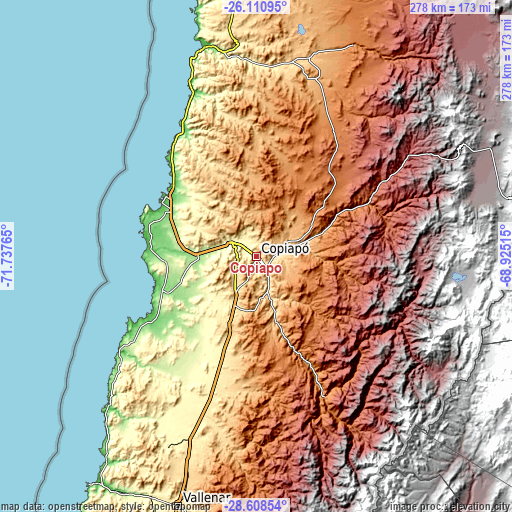
These maps also provides idea of topography and contour of this city, they are displayed at different zoom levels. More info about maps, scale and edge coordinates you can find below images.
| \ | Map #1 | Map #2 | Topo.Map |
| Scale [m] | 336..1001 m | 298..1179 m | × |
| Scale [ft] | 1102..3284 ft | 978..3868 ft | × |
| Average | 524.8 m = 1722 ft | 596.6 m = 1957 ft | × |
| Width | 8.68 km = 5.4 mi | 17.36 km = 10.8 mi | 277.7 km = 172.6 mi |
| Height | 8.68 km = 5.4 mi | 17.36 km = 10.8 mi | 277.7 km = 172.6 mi |
| ↑Max Latitude | -27.327756° | -27.288708° | -26.11095° |
| Latitude at center | -27.36679° | -27.36679° | -27.36679° |
| ↓Min Latitude | -27.40581° | -27.444817° | -28.60854° |
| ← Min Longitude | -70.375345° | -70.419291° | -71.73765° |
| Longitude center | -70.3314° | -70.3314° | -70.3314° |
| →Max Longitude | -70.287455° | -70.243509° | -68.92515° |
Nearby cities:
Cities around Copiapó sort by population:
• Antofagasta elevation 31 m
413.1 km,  359°
359°
• Coquimbo 22 m
303.9 km,  198°
198°
• La Serena 30 m
296 km, 197°
• Ovalle 218 m
369.4 km,  193°
193°
• Vallenar 388 m
140.9 km, 197°
• Diego de Almagro 1020 m
114.7 km,  14°
14°
• Monte Patria 429 m
375 km, 189°
• Vicuña 616 m
299 km, 187°
• Taltal 1 m
218.4 km, 355°
• Vallenar 1990 m
128 km,  176°
176°
• Chañaral 25 m
117.3 km,  346°
346°
Multilingual:
 En español:
Copiapó elevación 397 m.
 En France:
Copiapó élévation 397 m.


Sources and notes:
- [note 1] Map square and city borders are not equal. Map elevation data is calculated only from area inside that square.
- [src 1] Elevation data from geonames database provided with same terms of usage.
- [src 2] The elevation map of Copiapó is generated using elevation data from NASA's 3 arcsec (90m) resolution SRTM data.
- [src 3] Base (background) map © OpenStreetMap contributors tiles are generated by Geofabrik and OpenTopoMap.
Copyright & License:
This Copiapó Elevation Map is licensed under CC BY-SA. You may reuse any part from this page, if you give a proper credit by linking to this URL:
 More info on terms of use page.