Coquimbo elevation
Coquimbo (Coquimbo Region, Provincia de Elqui), Chile elevation is 22 meters and Coquimbo elevation in feet is 72 ft above sea level [src 1]. Coquimbo is a seat of a second-order administrative division (feature code) with elevation that is 253 meters (830 ft) smaller than average city elevation in Chile.
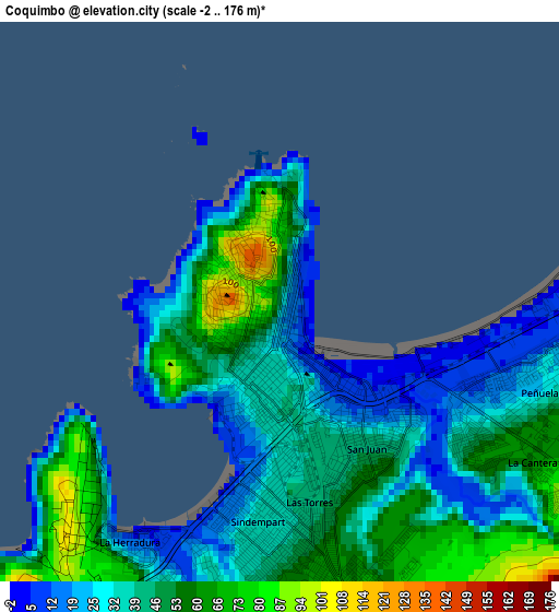
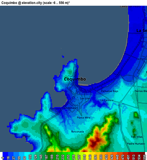
Below is the Elevation map of Coquimbo, which displays elevation range with different colors. Scale of the first map is from -2 to 176 m (-7 to 577 ft) with average elevation of 42.1 meters (=138 ft) [note 1]
These maps also provides idea of topography and contour of this city, they are displayed at different zoom levels. More info about maps, scale and edge coordinates you can find below images.
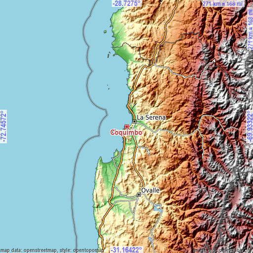
| \ | Map #1 | Map #2 | Topo.Map |
| Scale [m] | -2..176 m | -6..556 m | × |
| Scale [ft] | -7..577 ft | -20..1824 ft | × |
| Average | 42.1 m = 138 ft | 92.6 m = 304 ft | × |
| Width | 8.47 km = 5.3 mi | 16.93 km = 10.5 mi | 270.9 km = 168.3 mi |
| Height | 8.47 km = 5.3 mi | 16.93 km = 10.5 mi | 270.9 km = 168.3 mi |
| ↑Max Latitude | -29.915237° | -29.87714° | -28.7275° |
| Latitude at center | -29.95332° | -29.95332° | -29.95332° |
| ↓Min Latitude | -29.991388° | -30.029442° | -31.16422° |
| ← Min Longitude | -71.383415° | -71.427361° | -72.74572° |
| Longitude center | -71.33947° | -71.33947° | -71.33947° |
| →Max Longitude | -71.295525° | -71.251579° | -69.93322° |
Nearby cities:
Cities around Coquimbo sort by population:
• La Serena elevation 30 m
10.3 km,  58°
58°
• Copiapó 397 m
303.9 km,  18°
18°
• Ovalle 218 m
73.3 km,  169°
169°
• San Felipe 654 m
316.3 km, 169°
• Hacienda La Calera 203 m
314.9 km,  177°
177°
• Vallenar 388 m
163.1 km, 20°
• La Ligua 78 m
278.1 km, 177°
• Illapel 312 m
187.5 km, 175°
• Monte Patria 429 m
90.2 km,  156°
156°
• Vicuña 616 m
61 km,  98°
98°
• Salamanca 508 m
206.2 km, 169°
• Vallenar 1990 m
191.3 km,  33°
33°
Multilingual:
 En español:
Coquimbo elevación 22 m.
 En France:
Coquimbo élévation 22 m.


Sources and notes:
- [note 1] Map square and city borders are not equal. Map elevation data is calculated only from area inside that square.
- [src 1] Elevation data from geonames database provided with same terms of usage.
- [src 2] The elevation map of Coquimbo is generated using elevation data from NASA's 3 arcsec (90m) resolution SRTM data.
- [src 3] Base (background) map © OpenStreetMap contributors tiles are generated by Geofabrik and OpenTopoMap.
Copyright & License:
This Coquimbo Elevation Map is licensed under CC BY-SA. You may reuse any part from this page, if you give a proper credit by linking to this URL:
 More info on terms of use page.