Séguéla elevation
Séguéla (Woroba), Ivory Coast elevation is 350 meters and Séguéla elevation in feet is 1148 ft above sea level [src 1]. Séguéla is a seat of a first-order administrative division (feature code) with elevation that is 121 meters (397 ft) bigger than average city elevation in Ivory Coast.
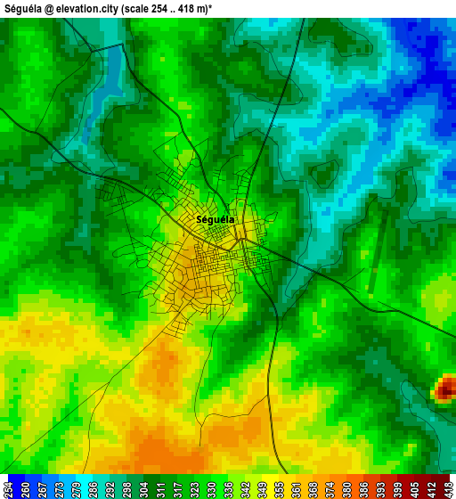
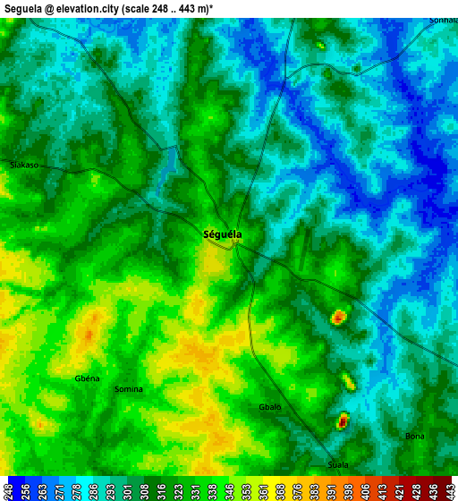
Below is the Elevation map of Séguéla, which displays elevation range with different colors. Scale of the first map is from 254 to 418 m (833 to 1371 ft) with average elevation of 320.6 meters (=1052 ft) [note 1]
These maps also provides idea of topography and contour of this city, they are displayed at different zoom levels. More info about maps, scale and edge coordinates you can find below images.
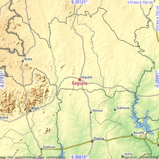
| \ | Map #1 | Map #2 | Topo.Map |
| Scale [m] | 254..418 m | 248..443 m | × |
| Scale [ft] | 833..1371 ft | 814..1453 ft | × |
| Average | 320.6 m = 1052 ft | 311.2 m = 1021 ft | × |
| Width | 9.68 km = 6 mi | 19.36 km = 12 mi | 309.7 km = 192.4 mi |
| Height | 9.68 km = 6 mi | 19.36 km = 12 mi | 309.7 km = 192.4 mi |
| ↑Max Latitude | 8.004629° | 8.048144° | 9.35131° |
| Latitude at center | 7.96111° | 7.96111° | 7.96111° |
| ↓Min Latitude | 7.917586° | 7.874057° | 6.56618° |
| ← Min Longitude | -6.717005° | -6.760951° | -8.07931° |
| Longitude center | -6.67306° | -6.67306° | -6.67306° |
| →Max Longitude | -6.629115° | -6.585169° | -5.26681° |
Nearby cities:
Cities around Séguéla sort by population:
• Man elevation 329 m
114.6 km,  237°
237°
• Zuénoula 207 m
90.5 km,  130°
130°
• Vavoua 276 m
67.9 km,  161°
161°
• Touba 470 m
116.8 km,  287°
287°
• Biankouma 538 m
106.5 km,  256°
256°
• Mankono 335 m
54.3 km,  78°
78°
• Dianra 369 m
118.5 km,  22°
22°
• Koro 429 m
109.2 km,  307°
307°
• Facobly 322 m
100.3 km,  230°
230°
• Kouibly 307 m
99.9 km,  218°
218°
• Kounahiri 301 m
94.2 km,  101°
101°
• Kani 356 m
58 km,  7°
7°
Multilingual:
 En español:
Séguéla elevación 350 m.
 En France:
Séguéla élévation 350 m.


Sources and notes:
- [note 1] Map square and city borders are not equal. Map elevation data is calculated only from area inside that square.
- [src 1] Elevation data from geonames database provided with same terms of usage.
- [src 2] The elevation map of Séguéla is generated using elevation data from NASA's 3 arcsec (90m) resolution SRTM data.
- [src 3] Base (background) map © OpenStreetMap contributors tiles are generated by Geofabrik and OpenTopoMap.
Copyright & License:
This Séguéla Elevation Map is licensed under CC BY-SA. You may reuse any part from this page, if you give a proper credit by linking to this URL:
 More info on terms of use page.