Touba elevation
Touba (Woroba, Bafing), Ivory Coast elevation is 470 meters and Touba elevation in feet is 1542 ft above sea level [src 1]. Touba is a seat of a second-order administrative division (feature code) with elevation that is 241 meters (791 ft) bigger than average city elevation in Ivory Coast.
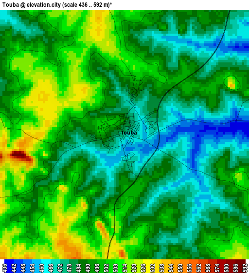
Below is the Elevation map of Touba, which displays elevation range with different colors. Scale of the first map is from 436 to 592 m (1430 to 1942 ft) with average elevation of 491.5 meters (=1613 ft) [note 1]
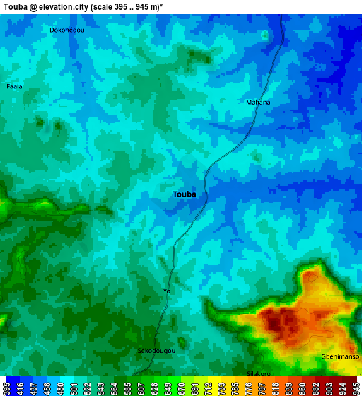
These maps also provides idea of topography and contour of this city, they are displayed at different zoom levels. More info about maps, scale and edge coordinates you can find below images.
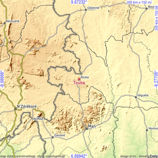
| \ | Map #1 | Map #2 | Topo.Map |
| Scale [m] | 436..592 m | 395..945 m | × |
| Scale [ft] | 1430..1942 ft | 1296..3100 ft | × |
| Average | 491.5 m = 1613 ft | 518.2 m = 1700 ft | × |
| Width | 9.67 km = 6 mi | 19.34 km = 12 mi | 309.4 km = 192.3 mi |
| Height | 9.67 km = 6 mi | 19.34 km = 12 mi | 309.5 km = 192.3 mi |
| ↑Max Latitude | 8.326814° | 8.370294° | 9.67232° |
| Latitude at center | 8.28333° | 8.28333° | 8.28333° |
| ↓Min Latitude | 8.239841° | 8.196347° | 6.88942° |
| ← Min Longitude | -7.727275° | -7.771221° | -9.08958° |
| Longitude center | -7.68333° | -7.68333° | -7.68333° |
| →Max Longitude | -7.639385° | -7.595439° | -6.27708° |
Nearby cities:
Cities around Touba sort by population:
• Man elevation 329 m
97.9 km,  171°
171°
• Danané 347 m
125.1 km,  204°
204°
• Séguéla 350 m
116.8 km,  107°
107°
• Odienné 429 m
136.5 km,  5°
5°
• Biankouma 538 m
61 km, 172°
• Séguélon 393 m
134.4 km,  27°
27°
• Kouibly 307 m
124.4 km,  156°
156°
• Kani 356 m
120.6 km,  79°
79°
• Facobly 322 m
105.1 km, 161°
• Sipilou 556 m
65.5 km,  224°
224°
• Koro 429 m
38.7 km,  38°
38°
• Ouaninou 541 m
20.8 km,  255°
255°
Multilingual:
 En español:
Touba elevación 470 m.
 En France:
Touba élévation 470 m.


Sources and notes:
- [note 1] Map square and city borders are not equal. Map elevation data is calculated only from area inside that square.
- [src 1] Elevation data from geonames database provided with same terms of usage.
- [src 2] The elevation map of Touba is generated using elevation data from NASA's 3 arcsec (90m) resolution SRTM data.
- [src 3] Base (background) map © OpenStreetMap contributors tiles are generated by Geofabrik and OpenTopoMap.
Copyright & License:
This Touba Elevation Map is licensed under CC BY-SA. You may reuse any part from this page, if you give a proper credit by linking to this URL:
 More info on terms of use page.