Kani elevation
Kani (Woroba), Ivory Coast elevation is 356 meters and Kani elevation in feet is 1168 ft above sea level [src 1]. Kani is a seat of a third-order administrative division (feature code) with elevation that is 127 meters (417 ft) bigger than average city elevation in Ivory Coast.
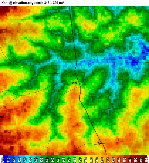
Below is the Elevation map of Kani, which displays elevation range with different colors. Scale of the first map is from 313 to 399 m (1027 to 1309 ft) with average elevation of 355.3 meters (=1166 ft) [note 1]
These maps also provides idea of topography and contour of this city, they are displayed at different zoom levels. More info about maps, scale and edge coordinates you can find below images.
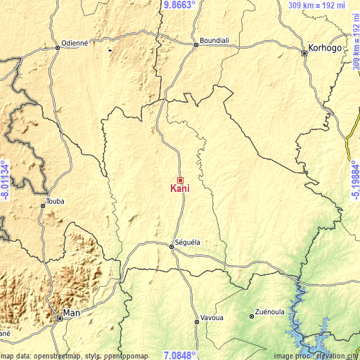
| \ | Map #1 | Topo.Map |
| Scale [m] | 313..399 m | × |
| Scale [ft] | 1027..1309 ft | × |
| Average | 355.3 m = 1166 ft | × |
| Width | 9.67 km = 6 mi | 309.3 km = 192.2 mi |
| Height | 9.67 km = 6 mi | 309.3 km = 192.2 mi |
| ↑Max Latitude | 8.521533° | 9.8663° |
| Latitude at center | 8.47807° | 8.47807° |
| ↓Min Latitude | 8.434602° | 7.0848° |
| ← Min Longitude | -6.649035° | -8.01134° |
| Longitude center | -6.60509° | -6.60509° |
| →Max Longitude | -6.561145° | -5.19884° |
Nearby cities:
Cities around Kani sort by population:
• Séguéla elevation 350 m
58 km,  187°
187°
• Boundiali 411 m
116.8 km,  6°
6°
• Zuénoula 207 m
131.5 km,  152°
152°
• Vavoua 276 m
122.7 km,  173°
173°
• Touba 470 m
120.6 km,  259°
259°
• Mankono 335 m
65.3 km,  135°
135°
• Madinani 514 m
131.3 km,  343°
343°
• Kounahiri 301 m
114.1 km,  132°
132°
• Séguélon 393 m
113 km,  329°
329°
• Dikodougou 409 m
112.6 km,  54°
54°
• Koro 429 m
94.8 km,  275°
275°
• Dianra 369 m
64.5 km,  36°
36°
Multilingual:
 En español:
Kani elevación 356 m.
 En France:
Kani élévation 356 m.


Sources and notes:
- [note 1] Map square and city borders are not equal. Map elevation data is calculated only from area inside that square.
- [src 1] Elevation data from geonames database provided with same terms of usage.
- [src 2] The elevation map of Kani is generated using elevation data from NASA's 3 arcsec (90m) resolution SRTM data.
- [src 3] Base (background) map © OpenStreetMap contributors tiles are generated by Geofabrik and OpenTopoMap.
Copyright & License:
This Kani Elevation Map is licensed under CC BY-SA. You may reuse any part from this page, if you give a proper credit by linking to this URL:
 More info on terms of use page.