Béttié elevation
Béttié (Comoé), Ivory Coast elevation is 113 meters and Béttié elevation in feet is 371 ft above sea level [src 1]. Béttié is a seat of a third-order administrative division (feature code) with elevation that is 116 meters (381 ft) smaller than average city elevation in Ivory Coast.
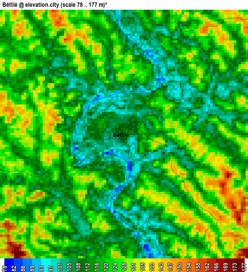
Below is the Elevation map of Béttié, which displays elevation range with different colors. Scale of the first map is from 78 to 177 m (256 to 581 ft) with average elevation of 119 meters (=390 ft) [note 1]
These maps also provides idea of topography and contour of this city, they are displayed at different zoom levels. More info about maps, scale and edge coordinates you can find below images.
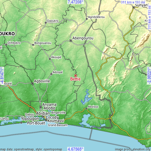
| \ | Map #1 | Topo.Map |
| Scale [m] | 78..177 m | × |
| Scale [ft] | 256..581 ft | × |
| Average | 119 m = 390 ft | × |
| Width | 9.72 km = 6 mi | 310.9 km = 193.2 mi |
| Height | 9.72 km = 6 mi | 311 km = 193.2 mi |
| ↑Max Latitude | 6.119377° | 7.47208° |
| Latitude at center | 6.07568° | 6.07568° |
| ↓Min Latitude | 6.03198° | 4.67565° |
| ← Min Longitude | -3.452405° | -4.81471° |
| Longitude center | -3.40846° | -3.40846° |
| →Max Longitude | -3.364515° | -2.00221° |
Nearby cities:
Cities around Béttié sort by population:
• Abengourou elevation 197 m
73.4 km,  352°
352°
• Agboville 35 m
90.5 km,  259°
259°
• Adzopé 109 m
50.3 km,  273°
273°
• Aboisso 12 m
71.2 km,  161°
161°
• Arrah 143 m
90.9 km,  316°
316°
• Bonoua 30 m
91.7 km,  193°
193°
• Akoupé 142 m
63.1 km,  302°
302°
• Affery 106 m
66 km,  294°
294°
• Adiaké 40 m
88.5 km,  172°
172°
• Ayamé 82 m
59.2 km,  152°
152°
• Alépé 13 m
69.9 km,  203°
203°
• Yakassé-Attobrou 144 m
29.3 km, 293°
Multilingual:
 En español:
Béttié elevación 113 m.
 En France:
Béttié élévation 113 m.


Sources and notes:
- [note 1] Map square and city borders are not equal. Map elevation data is calculated only from area inside that square.
- [src 1] Elevation data from geonames database provided with same terms of usage.
- [src 2] The elevation map of Béttié is generated using elevation data from NASA's 3 arcsec (90m) resolution SRTM data.
- [src 3] Base (background) map © OpenStreetMap contributors tiles are generated by Geofabrik and OpenTopoMap.
Copyright & License:
This Béttié Elevation Map is licensed under CC BY-SA. You may reuse any part from this page, if you give a proper credit by linking to this URL:
 More info on terms of use page.