Dabakala elevation
Dabakala (Vallée du Bandama), Ivory Coast elevation is 254 meters and Dabakala elevation in feet is 833 ft above sea level [src 1]. Dabakala is a seat of a third-order administrative division (feature code) with elevation that is 25 meters (82 ft) bigger than average city elevation in Ivory Coast.
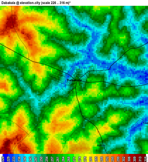
Below is the Elevation map of Dabakala, which displays elevation range with different colors. Scale of the first map is from 226 to 316 m (741 to 1037 ft) with average elevation of 262.1 meters (=860 ft) [note 1]
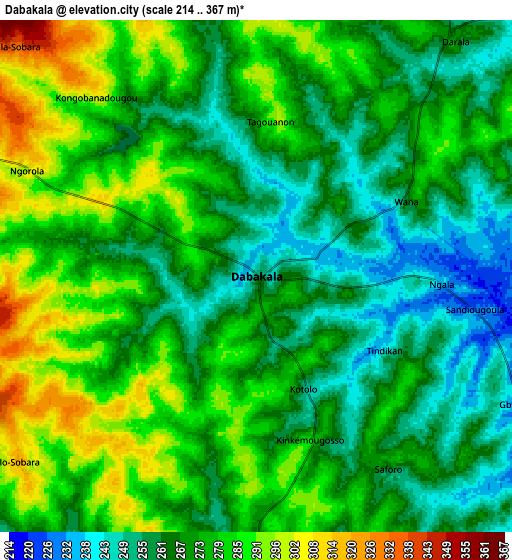
These maps also provides idea of topography and contour of this city, they are displayed at different zoom levels. More info about maps, scale and edge coordinates you can find below images.
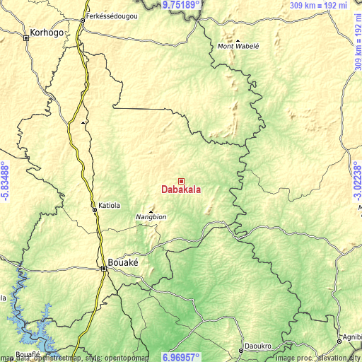
| \ | Map #1 | Map #2 | Topo.Map |
| Scale [m] | 226..316 m | 214..367 m | × |
| Scale [ft] | 741..1037 ft | 702..1204 ft | × |
| Average | 262.1 m = 860 ft | 272 m = 892 ft | × |
| Width | 9.67 km = 6 mi | 19.34 km = 12 mi | 309.4 km = 192.3 mi |
| Height | 9.67 km = 6 mi | 19.34 km = 12 mi | 309.4 km = 192.3 mi |
| ↑Max Latitude | 8.406686° | 8.450156° | 9.75189° |
| Latitude at center | 8.36321° | 8.36321° | 8.36321° |
| ↓Min Latitude | 8.31973° | 8.276244° | 6.96957° |
| ← Min Longitude | -4.472575° | -4.516521° | -5.83488° |
| Longitude center | -4.42863° | -4.42863° | -4.42863° |
| →Max Longitude | -4.384685° | -4.340739° | -3.02238° |
Nearby cities:
Cities around Dabakala sort by population:
• Bouaké elevation 339 m
99.6 km,  221°
221°
• Katiola 326 m
78.1 km,  251°
251°
• Sakassou 231 m
138.8 km, 223°
• Botro 261 m
112.5 km,  239°
239°
• Bocanda 115 m
144.8 km,  183°
183°
• Kouassi-Kouassikro 238 m
116.9 km,  193°
193°
• Nassian 353 m
105.7 km,  84°
84°
• Sandégué 201 m
103.9 km,  115°
115°
• M’Bahiakro 127 m
101.2 km,  174°
174°
• Niakaramandougou 385 m
100.3 km,  289°
289°
• Prikro 213 m
92.8 km,  149°
149°
• Kong 327 m
89.7 km,  347°
347°
Multilingual:
 En español:
Dabakala elevación 254 m.
 En France:
Dabakala élévation 254 m.
 Auf Deutsch:
Dabakala höhe über dem Meeresspiegel ist 254 m.

Sources and notes:
- [note 1] Map square and city borders are not equal. Map elevation data is calculated only from area inside that square.
- [src 1] Elevation data from geonames database provided with same terms of usage.
- [src 2] The elevation map of Dabakala is generated using elevation data from NASA's 3 arcsec (90m) resolution SRTM data.
- [src 3] Base (background) map © OpenStreetMap contributors tiles are generated by Geofabrik and OpenTopoMap.
Copyright & License:
This Dabakala Elevation Map is licensed under CC BY-SA. You may reuse any part from this page, if you give a proper credit by linking to this URL:
 More info on terms of use page.