Bocanda elevation
Bocanda (Lacs), Ivory Coast elevation is 115 meters and Bocanda elevation in feet is 377 ft above sea level [src 1]. Bocanda is a seat of a third-order administrative division (feature code) with elevation that is 114 meters (374 ft) smaller than average city elevation in Ivory Coast.
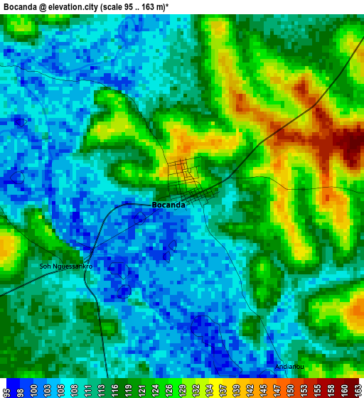
Below is the Elevation map of Bocanda, which displays elevation range with different colors. Scale of the first map is from 95 to 163 m (312 to 535 ft) with average elevation of 115.9 meters (=380 ft) [note 1]
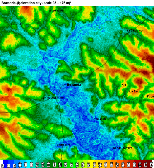
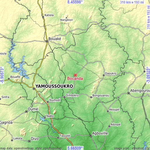
These maps also provides idea of topography and contour of this city, they are displayed at different zoom levels. More info about maps, scale and edge coordinates you can find below images.
| \ | Map #1 | Map #2 | Topo.Map |
| Scale [m] | 95..163 m | 93..176 m | × |
| Scale [ft] | 312..535 ft | 305..577 ft | × |
| Average | 115.9 m = 380 ft | 123.1 m = 404 ft | × |
| Width | 9.7 km = 6 mi | 19.4 km = 12.1 mi | 310.3 km = 192.8 mi |
| Height | 9.7 km = 6 mi | 19.4 km = 12.1 mi | 310.3 km = 192.8 mi |
| ↑Max Latitude | 7.10625° | 7.149855° | 8.45598° |
| Latitude at center | 7.06264° | 7.06264° | 7.06264° |
| ↓Min Latitude | 7.019026° | 6.975408° | 5.66509° |
| ← Min Longitude | -4.543425° | -4.587371° | -5.90573° |
| Longitude center | -4.49948° | -4.49948° | -4.49948° |
| →Max Longitude | -4.455535° | -4.411589° | -3.09323° |
Nearby cities:
Cities around Bocanda sort by population:
• Dimbokro elevation 94 m
51.5 km,  206°
206°
• Daoukro 188 m
59.2 km,  90°
90°
• Toumodi 159 m
80.1 km,  225°
225°
• Arrah 143 m
72.8 km,  126°
126°
• Bongouanou 213 m
56.1 km,  144°
144°
• Prikro 213 m
85.5 km,  40°
40°
• Tiébissou 194 m
80.7 km,  277°
277°
• Attiégouakro 212 m
75.1 km,  244°
244°
• M’Batto 124 m
67.5 km,  166°
166°
• M’Bahiakro 127 m
47.3 km,  21°
21°
• Didiévi 172 m
44.6 km, 279°
• Kouassi-Kouassikro 238 m
36.7 km,  327°
327°
Multilingual:
 En español:
Bocanda elevación 115 m.
 En France:
Bocanda élévation 115 m.


Sources and notes:
- [note 1] Map square and city borders are not equal. Map elevation data is calculated only from area inside that square.
- [src 1] Elevation data from geonames database provided with same terms of usage.
- [src 2] The elevation map of Bocanda is generated using elevation data from NASA's 3 arcsec (90m) resolution SRTM data.
- [src 3] Base (background) map © OpenStreetMap contributors tiles are generated by Geofabrik and OpenTopoMap.
Copyright & License:
This Bocanda Elevation Map is licensed under CC BY-SA. You may reuse any part from this page, if you give a proper credit by linking to this URL:
 More info on terms of use page.