San-Pédro elevation
San-Pédro (Bas-Sassandra), Ivory Coast elevation is 9 meters and San-Pédro elevation in feet is 30 ft above sea level [src 1]. San-Pédro is a seat of a first-order administrative division (feature code) with elevation that is 220 meters (722 ft) smaller than average city elevation in Ivory Coast.
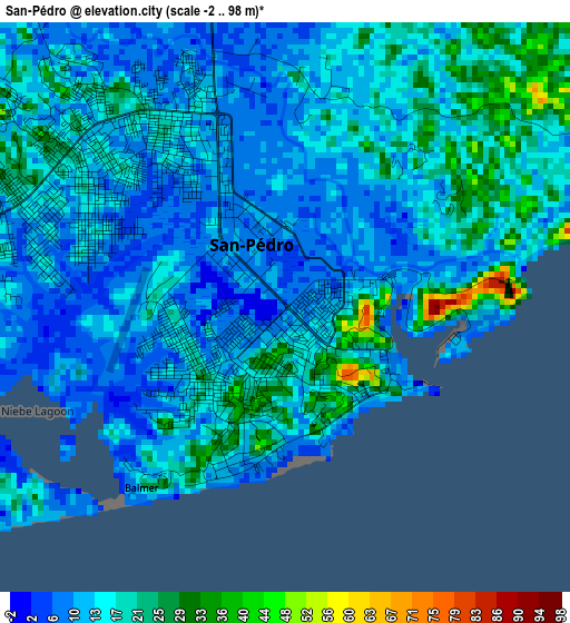
Below is the Elevation map of San-Pédro, which displays elevation range with different colors. Scale of the first map is from -2 to 98 m (-7 to 322 ft) with average elevation of 15 meters (=49 ft) [note 1]
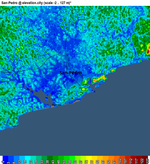
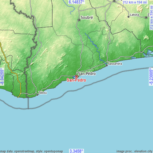
These maps also provides idea of topography and contour of this city, they are displayed at different zoom levels. More info about maps, scale and edge coordinates you can find below images.
| \ | Map #1 | Map #2 | Topo.Map |
| Scale [m] | -2..98 m | -2..127 m | × |
| Scale [ft] | -7..322 ft | -7..417 ft | × |
| Average | 15 m = 49 ft | 19.8 m = 65 ft | × |
| Width | 9.74 km = 6.1 mi | 19.48 km = 12.1 mi | 311.6 km = 193.6 mi |
| Height | 9.74 km = 6.1 mi | 19.48 km = 12.1 mi | 311.6 km = 193.6 mi |
| ↑Max Latitude | 4.792303° | 4.836093° | 6.14837° |
| Latitude at center | 4.74851° | 4.74851° | 4.74851° |
| ↓Min Latitude | 4.704714° | 4.660916° | 3.3458° |
| ← Min Longitude | -6.680245° | -6.724191° | -8.04255° |
| Longitude center | -6.6363° | -6.6363° | -6.6363° |
| →Max Longitude | -6.592355° | -6.548409° | -5.23005° |
Nearby cities:
Cities around San-Pédro sort by population:
• Divo elevation 147 m
186.3 km,  49°
49°
• Gagnoa 202 m
171.5 km,  26°
26°
• Lakota 228 m
161.5 km,  40°
40°
• Sassandra 38 m
65.2 km,  69°
69°
• Tabou 9 m
87.3 km,  245°
245°
• Guibéroua 230 m
173.5 km,  17°
17°
• Guitry 41 m
176.8 km,  60°
60°
• Buyo 229 m
174.4 km,  346°
346°
• Taï 166 m
154.5 km,  324°
324°
• Fresco 69 m
123.9 km, 72°
• Guéyo 188 m
121.8 km, 30°
• Soubré 140 m
115.2 km,  2°
2°
Multilingual:
 En español:
San Pedro elevación 9 m.
 En France:
San-Pédro élévation 9 m.


Sources and notes:
- [note 1] Map square and city borders are not equal. Map elevation data is calculated only from area inside that square.
- [src 1] Elevation data from geonames database provided with same terms of usage.
- [src 2] The elevation map of San-Pédro is generated using elevation data from NASA's 3 arcsec (90m) resolution SRTM data.
- [src 3] Base (background) map © OpenStreetMap contributors tiles are generated by Geofabrik and OpenTopoMap.
Copyright & License:
This San-Pédro Elevation Map is licensed under CC BY-SA. You may reuse any part from this page, if you give a proper credit by linking to this URL:
 More info on terms of use page.