Lakota elevation
Lakota (Gôh-Djiboua, Lôh-Djiboua), Ivory Coast elevation is 228 meters and Lakota elevation in feet is 748 ft above sea level [src 1]. Lakota is a seat of a third-order administrative division (feature code) with elevation that is 1 meters (3 ft) smaller than average city elevation in Ivory Coast.
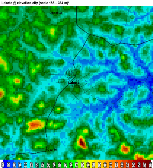
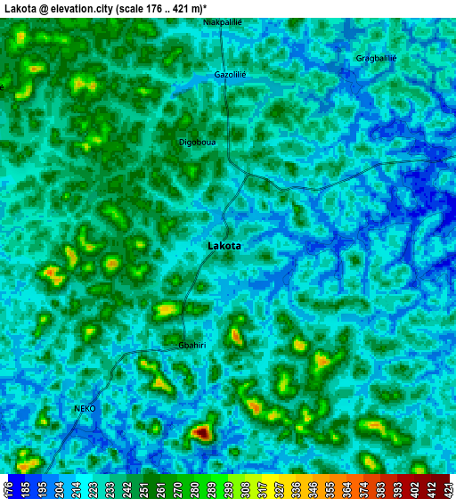
Below is the Elevation map of Lakota, which displays elevation range with different colors. Scale of the first map is from 186 to 364 m (610 to 1194 ft) with average elevation of 232.5 meters (=763 ft) [note 1]
These maps also provides idea of topography and contour of this city, they are displayed at different zoom levels. More info about maps, scale and edge coordinates you can find below images.
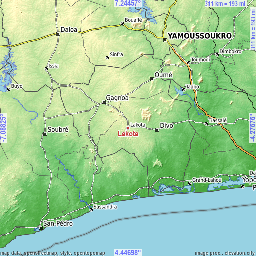
| \ | Map #1 | Map #2 | Topo.Map |
| Scale [m] | 186..364 m | 176..421 m | × |
| Scale [ft] | 610..1194 ft | 577..1381 ft | × |
| Average | 232.5 m = 763 ft | 230.8 m = 757 ft | × |
| Width | 9.72 km = 6 mi | 19.44 km = 12.1 mi | 311.1 km = 193.3 mi |
| Height | 9.72 km = 6 mi | 19.44 km = 12.1 mi | 311.1 km = 193.3 mi |
| ↑Max Latitude | 5.891235° | 5.934946° | 7.24457° |
| Latitude at center | 5.84752° | 5.84752° | 5.84752° |
| ↓Min Latitude | 5.803802° | 5.76008° | 4.44698° |
| ← Min Longitude | -5.725945° | -5.769891° | -7.08825° |
| Longitude center | -5.682° | -5.682° | -5.682° |
| →Max Longitude | -5.638055° | -5.594109° | -4.27575° |
Nearby cities:
Cities around Lakota sort by population:
• Divo elevation 147 m
35.9 km,  91°
91°
• Gagnoa 202 m
43.4 km,  316°
316°
• Sinfra 265 m
89.7 km,  343°
343°
• Oumé 211 m
66.3 km,  26°
26°
• Tiassalé 29 m
95.2 km, 86°
• Guibéroua 230 m
69.4 km,  308°
308°
• Grand-Lahou 77 m
100.2 km,  131°
131°
• Djékanou 177 m
94.5 km,  41°
41°
• Fresco 69 m
86 km,  171°
171°
• Taabo 139 m
74.5 km,  58°
58°
• Guitry 41 m
61 km, 126°
• Guéyo 188 m
46.6 km,  247°
247°
Multilingual:
 En español:
Lakota elevación 228 m.
 En France:
Lakota élévation 228 m.


Sources and notes:
- [note 1] Map square and city borders are not equal. Map elevation data is calculated only from area inside that square.
- [src 1] Elevation data from geonames database provided with same terms of usage.
- [src 2] The elevation map of Lakota is generated using elevation data from NASA's 3 arcsec (90m) resolution SRTM data.
- [src 3] Base (background) map © OpenStreetMap contributors tiles are generated by Geofabrik and OpenTopoMap.
Copyright & License:
This Lakota Elevation Map is licensed under CC BY-SA. You may reuse any part from this page, if you give a proper credit by linking to this URL:
 More info on terms of use page.